🗺️ Arkansas County Map (With and Without Labels)
Arkansas, located in the southern United States, is known for its beautiful rivers, mountains, and forests. The state is divided into 75 counties, each with its own local history and charm. This Arkansas County Map helps you easily identify and learn about every county in the state — available in two versions: with labels and blank without labels.
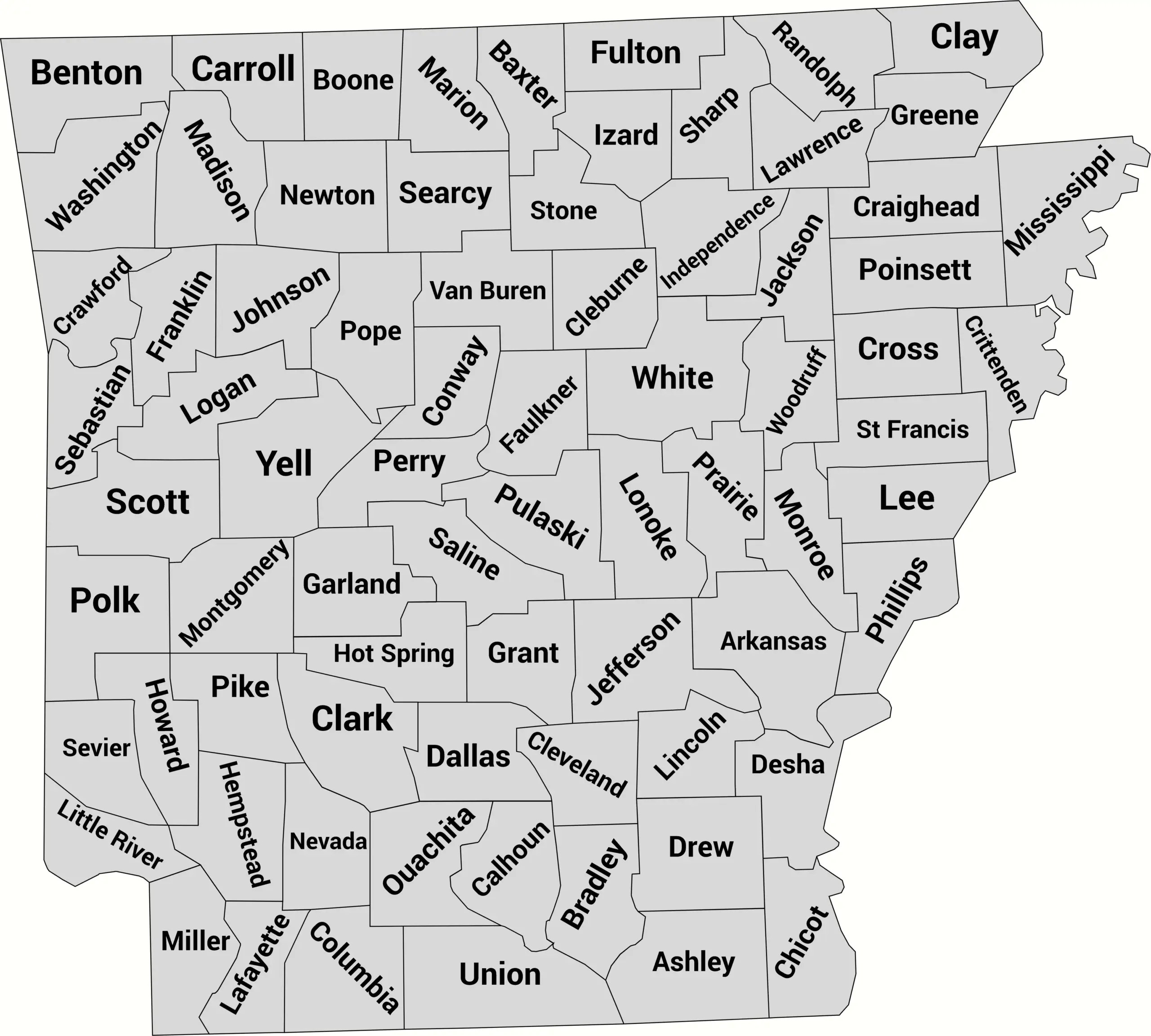
📍 Arkansas County Map with Labels
Below is a labeled county map of Arkansas, showing all 75 county borders with their names clearly marked.
This version is great for studying geography, exploring regional divisions, or visualizing demographic and historical data.
🖼️ Arkansas County Map (with labels):
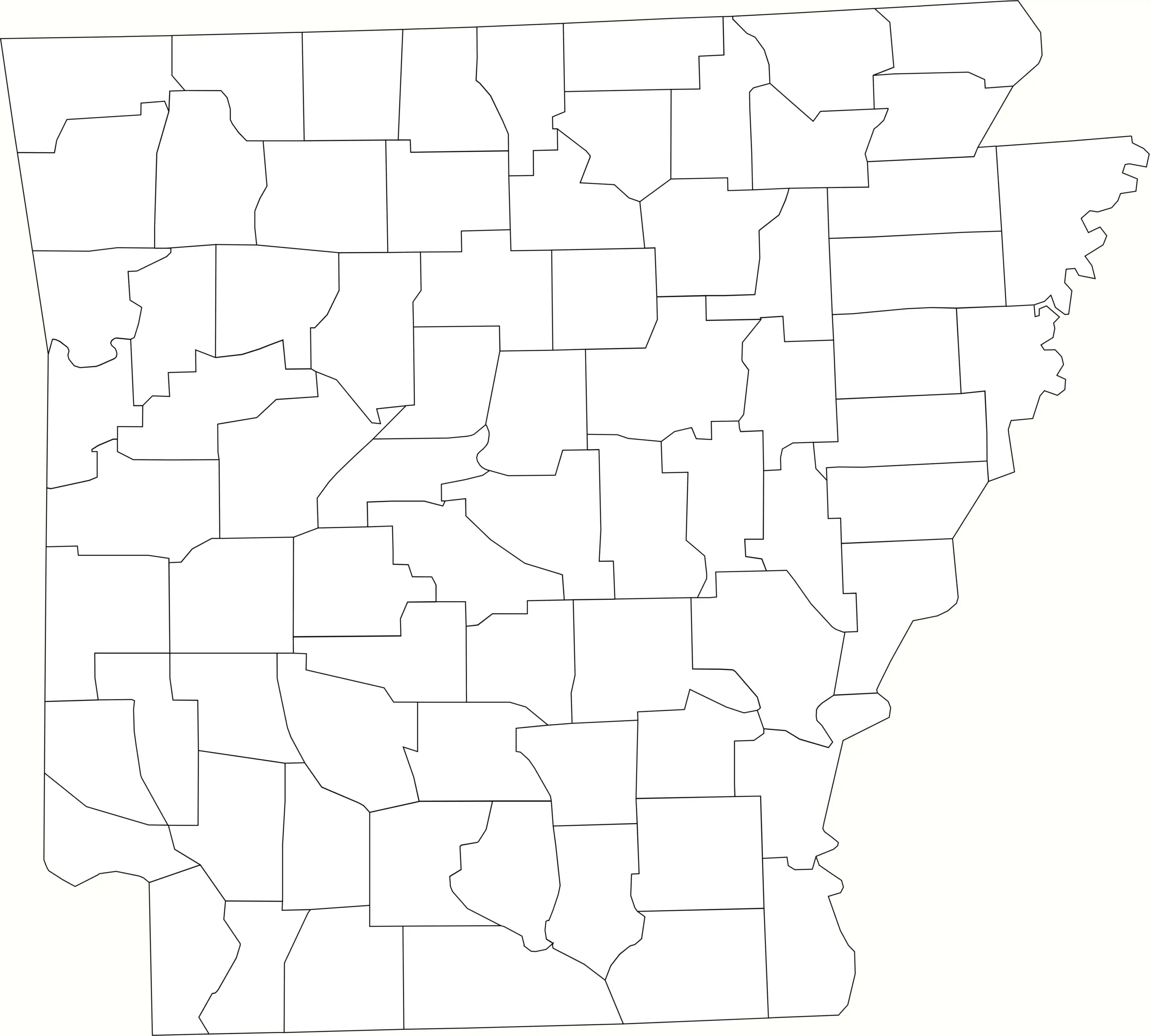
🌄 Blank Arkansas County Map (No Labels)
If you’re teaching or studying Arkansas geography, this blank county map is perfect for labeling exercises, quizzes, and classroom activities. You can also use it for coloring or custom map projects.
🖼️ Arkansas County Map (without labels):
🧭 About Arkansas’s Counties
Arkansas has a mix of urban centers, small towns, and rural regions — all represented by its 75 counties. Here are a few notable ones:
- Pulaski County — Home to Little Rock, the state capital and largest city.
- Benton County — A rapidly growing area in northwest Arkansas, part of the Fayetteville metro region.
- Washington County — Known for the University of Arkansas and a thriving local economy.
- Garland County — Contains Hot Springs National Park, a popular tourist destination.
From the Ozark Mountains in the north to the Delta lowlands in the east, each county offers a glimpse into Arkansas’s diverse geography.
🧾 Uses for the Arkansas County Map
These maps are perfect for:
✅ Educational lessons and classroom handouts
✅ Geography quizzes and labeling exercises
✅ Travel and regional planning
✅ Business and data visualization projects
✅ Art or creative design work
📥 Download Arkansas County Maps
Get your free copies of the Arkansas county map below:
Both are printable and free for personal and educational use.
Arkansas Counties by Population (2025 estimates)
Below is a complete list of all 75 counties in Arkansas with their 2025 estimated populations. Pulaski County (home to Little Rock) is the largest county by population, while Calhoun County is the smallest. Use this table for reference, research, or to build data visualizations for your Arkansas county map post.
| County | Population (2025 est.) |
|---|---|
| Pulaski County | 401,253 |
| Benton County | 327,395 |
| Washington County | 271,283 |
| Faulkner County | 134,723 |
| Saline County | 133,892 |
| Sebastian County | 129,076 |
| Craighead County | 116,253 |
| Garland County | 99,388 |
| White County | 80,124 |
| Lonoke County | 77,434 |
| Pope County | 65,673 |
| Crawford County | 63,591 |
| Jefferson County | 62,393 |
| Greene County | 47,413 |
| Crittenden County | 47,315 |
| Baxter County | 43,655 |
| Miller County | 42,029 |
| Boone County | 39,030 |
| Independence County | 38,452 |
| Mississippi County | 38,263 |
| Union County | 36,565 |
| Hot Spring County | 33,476 |
| Carroll County | 29,008 |
| Johnson County | 26,447 |
| Cleburne County | 25,829 |
| Poinsett County | 22,285 |
| Columbia County | 21,878 |
| Logan County | 21,684 |
| St. Francis County | 21,499 |
| Ouachita County | 21,391 |
| Clark County | 21,270 |
| Conway County | 21,189 |
| Yell County | 19,950 |
| Polk County | 19,640 |
| Hempstead County | 19,067 |
| Randolph County | 19,017 |
| Grant County | 18,891 |
| Madison County | 18,399 |
| Sharp County | 18,232 |
| Ashley County | 18,090 |
| Marion County | 17,964 |
| Franklin County | 17,864 |
| Jackson County | 17,044 |
| Drew County | 17,011 |
| Lawrence County | 16,566 |
| Van Buren County | 16,220 |
| Cross County | 16,080 |
| Arkansas County | 15,925 |
| Sevier County | 15,420 |
| Izard County | 14,449 |
| Phillips County | 14,183 |
| Clay County | 14,061 |
| Lincoln County | 12,874 |
| Stone County | 12,843 |
| Fulton County | 12,553 |
| Howard County | 12,355 |
| Little River County | 11,685 |
| Perry County | 10,406 |
| Pike County | 10,306 |
| Bradley County | 9,976 |
| Scott County | 9,961 |
| Desha County | 9,921 |
| Chicot County | 8,946 |
| Montgomery County | 8,774 |
| Nevada County | 8,002 |
| Prairie County | 7,954 |
| Lee County | 7,869 |
| Searcy County | 7,606 |
| Cleveland County | 7,200 |
| Newton County | 7,011 |
| Monroe County | 6,400 |
| Dallas County | 6,163 |
| Lafayette County | 6,027 |
| Woodruff County | 5,778 |
| Calhoun County | 4,549 |
Notes: Population figures are 2025 estimates from World Population Review (which compiles Census Bureau estimates). For the most current official figures, see the U.S. Census Bureau’s Vintage 2024 county estimates.
❓ Frequently Asked Questions About Arkansas Counties
How many counties are in Arkansas?
Arkansas has 75 counties in total. These counties cover everything from the Ozark Mountains in the north to the Mississippi Delta in the east.
What is the largest county in Arkansas by population?
Pulaski County, which includes Little Rock (the state capital), is the most populated county in Arkansas.
Which county is the smallest by population?
Calhoun County has the smallest population in the state, with fewer than 5,000 residents.
What is the largest county by land area?
Union County in southern Arkansas is the largest by land area, spanning over 1,000 square miles.
When were Arkansas’s counties established?
Most Arkansas counties were formed between 1820 and 1880, as the state’s population grew westward.
What counties make up the Little Rock metropolitan area?
The Little Rock metro area includes Pulaski, Saline, Faulkner, and Lonoke counties.
Which counties border other states?
Several counties in Arkansas border other U.S. states:
- Mississippi County – borders Missouri and Tennessee
- Benton and Washington Counties – border Missouri and Oklahoma
- Miller County – borders Texas and Louisiana
What is the oldest county in Arkansas?
Arkansas County is the oldest, established in 1813 when the area was still part of the Missouri Territory.
What is the most rural county in Arkansas?
Counties like Newton, Searcy, and Marion are among the most rural, with low population densities and scenic landscapes in the Ozarks.
Where can I download a map of Arkansas counties?
You can find both labeled maps with county names and blank county outline maps for educational or design use on this page.


