🗺️ California County Map (With and Without Cities)
California — the Golden State — is home to beaches, mountains, deserts, and some of the most iconic cities in the world. The state is divided into 58 counties, each with its own unique geography, culture, and history. This California County Map lets you explore them all, with two downloadable versions: one with county labels and one blank without labels for quizzes and custom use.
📍 California County Map with Labels
The labeled California county map below shows all 58 counties clearly marked. It’s perfect for studying, referencing, or learning more about California’s regional layout — from the northern redwoods to the southern deserts.
🖼️ California County Map (with labels):
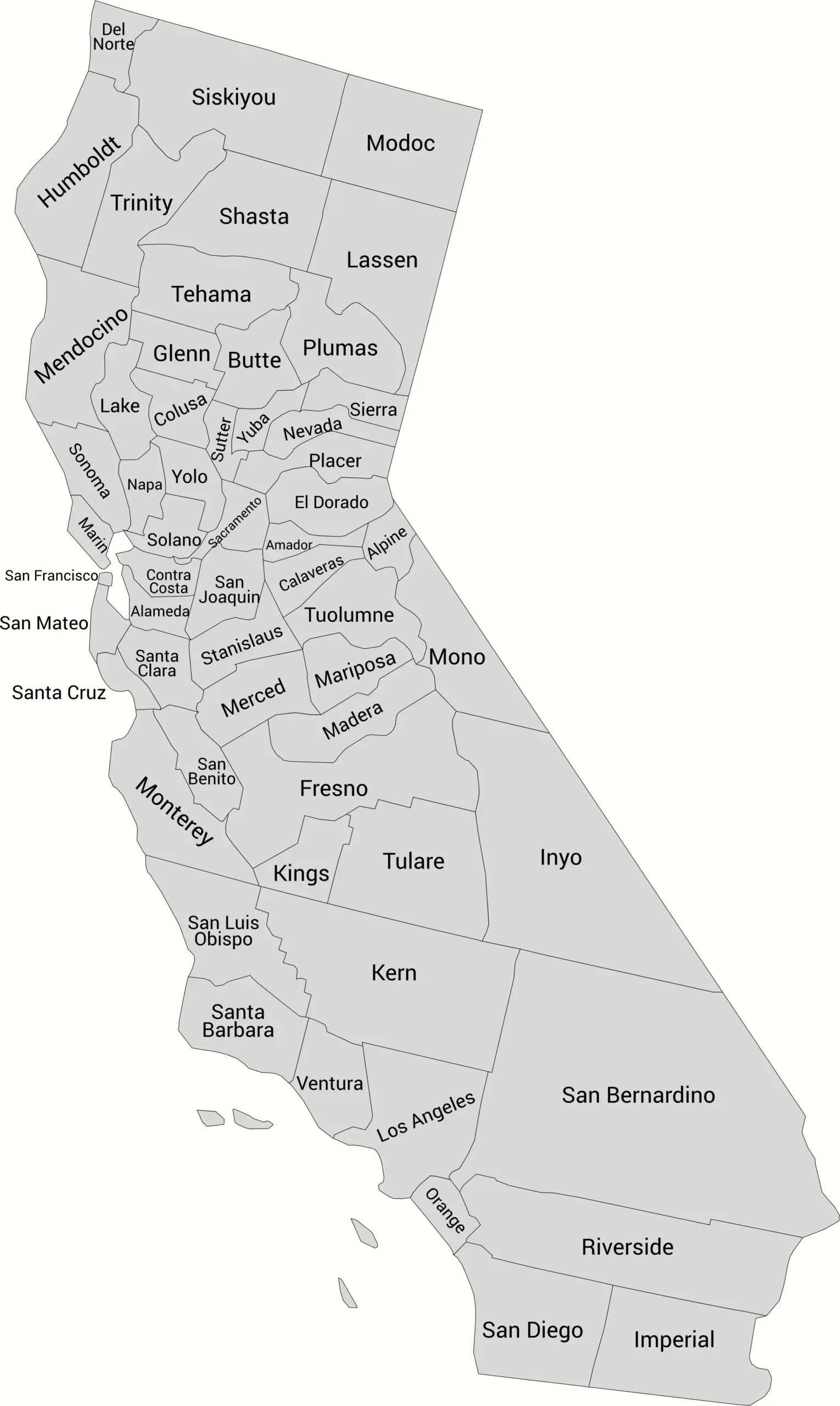
Download Labeled California County Map (WebP)
🌄 Blank California County Map (No Labels)
For teachers, students, and geography enthusiasts, here’s a blank version of the California county map. This one is great for labeling practice, school assignments, or coloring projects.
🖼️ California County Map (without labels):
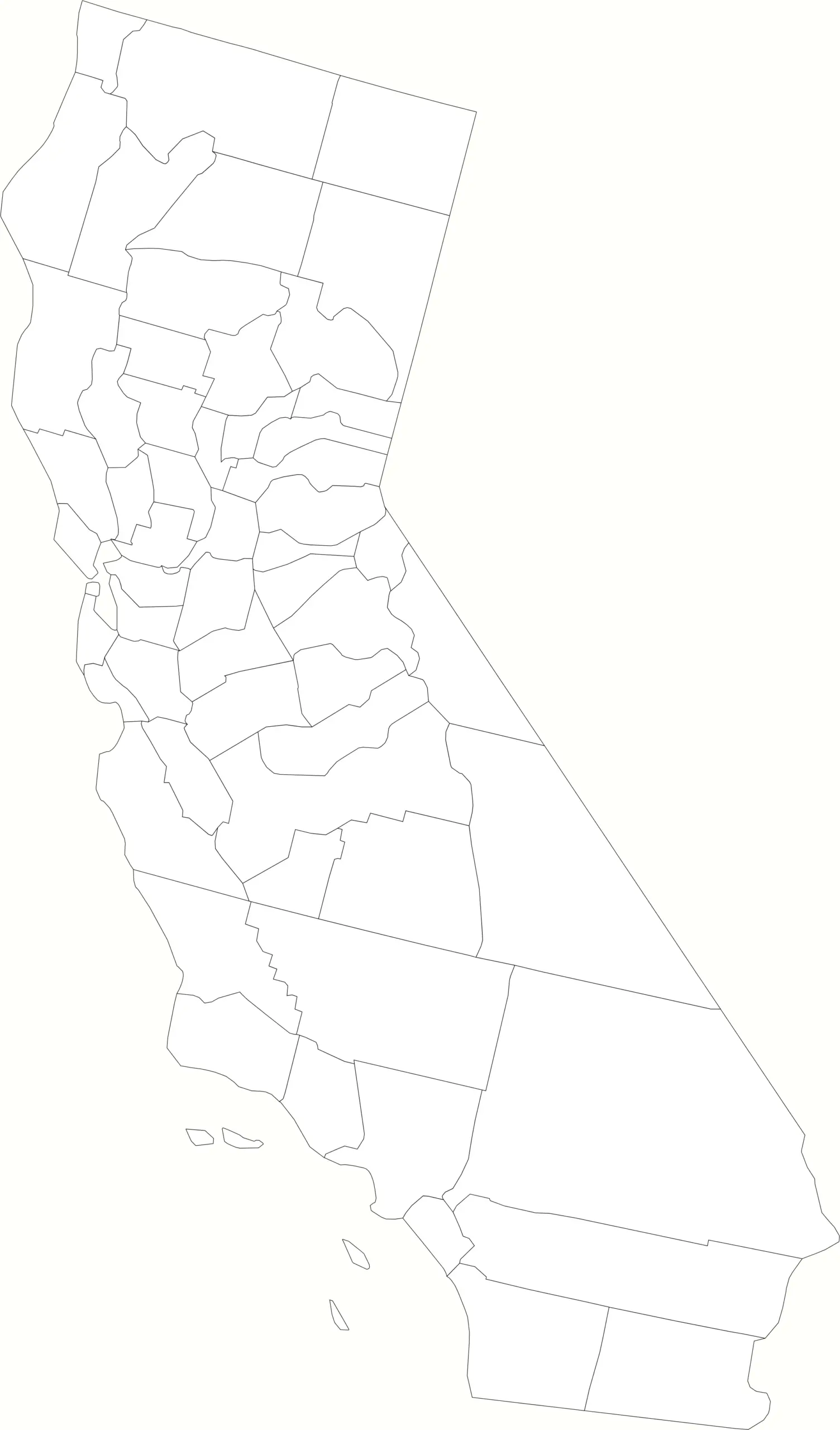
Download Blank California County Map (WebP)
🧭 About California’s Counties
California’s 58 counties range from bustling coastal areas to vast mountain and desert regions.
Here are a few of the most notable:
- Los Angeles County — The most populous county in the United States.
- San Diego County — Known for its beautiful beaches and perfect weather.
- Orange County — Home to Disneyland and famous coastal communities.
- San Francisco County — The heart of Northern California’s Bay Area.
- Sacramento County — The state capital and a hub of government and history.
From the Sierra Nevada mountains to the Pacific Coast, each county contributes to California’s incredible diversity.
🧾 Uses for the California County Map
You can use these maps for many purposes, including:
✅ Classroom and educational materials
✅ Travel and regional planning
✅ Geography quizzes and student projects
✅ Business and demographic mapping
✅ Coloring or art projects
📥 Download California County Maps
Get free printable copies of both versions below:
Both maps are high-resolution, printable, and great for educational or personal use.
List of California Counties and their population estimates
Find a complete alphabetical list of California counties with their 2024 population estimates based on the latest data.
| County | Population Estimate (2024) |
|---|---|
| Alameda | 1,610,046 |
| Alpine | 1,043 |
| Amador | 42,026 |
| Butte | 206,778 |
| Calaveras | 46,108 |
| Colusa | 21,754 |
| Contra Costa | 1,151,037 |
| Del Norte | 27,093 |
| El Dorado | 191,071 |
| Fresno | 1,020,768 |
| Glenn | 28,173 |
| Humboldt | 133,517 |
| Imperial | 179,291 |
| Inyo | 18,097 |
| Kern | 907,958 |
| Kings | 152,300 |
| Lake | 67,834 |
| Lassen | 29,001 |
| Los Angeles | 9,757,179 |
| Madera | 167,916 |
| Marin | 250,913 |
| Mariposa | 16,651 |
| Mendocino | 86,614 |
| Merced | 295,340 |
| Modoc | 8,262 |
| Mono | 13,194 |
| Monterey | 426,401 |
| Napa | 139,000 |
| Nevada | 102,501 |
| Orange | 3,170,435 |
| Placer | 434,535 |
| Plumas | 18,507 |
| Riverside | 2,529,933 |
| Sacramento | 1,584,104 |
| San Benito | 67,715 |
| San Bernardino | 2,214,281 |
| San Diego | 3,298,799 |
| San Francisco | 811,416 |
| San Joaquin | 814,309 |
| San Luis Obispo | 280,825 |
| San Mateo | 721,201 |
| Santa Barbara | 435,941 |
| Santa Clara | 1,876,106 |
| Santa Cruz | 256,161 |
| Shasta | 179,224 |
| Sierra | 3,156 |
| Siskiyou | 43,661 |
| Solano | 449,884 |
| Sonoma | 480,098 |
| Stanislaus | 551,838 |
| Sutter | 101,199 |
| Tehama | 64,512 |
| Trinity | 15,454 |
| Tulare | 482,636 |
| Tuolumne | 54,256 |
| Ventura | 823,028 |
| Yolo | 217,596 |
| Yuba | 83,116 |
🧠 Frequently Asked Questions About the California County Map
How many counties are in California?
California has 58 counties, making it one of the states with the largest number of counties in the U.S.
Which is the largest county by population?
Los Angeles County is the most populous county in California — and in the entire United States — with more than 9.6 million residents.
Which county is the largest by land area?
San Bernardino County is the largest county by land area in the U.S., covering more than 20,000 square miles.
What is the smallest county in California?
San Francisco County is the smallest by land area. It is a consolidated city-county, meaning the city and county governments are the same.
Does California use counties for local government?
Yes. Counties in California play a major role in local government, providing services such as law enforcement, courts, public health, and elections.
What is the California county map with labels used for?
A labeled county map is useful for learning geography, planning travel, understanding population distribution, and identifying county boundaries across the state.
What is the blank California county map used for?
The blank county map is ideal for educational labeling, classroom quizzes, homeschooling, presentations, or custom mapping projects.
Are California counties divided into regions?
Yes. Counties are often grouped into regions such as Northern California, Southern California, Central Valley, Bay Area, Inland Empire, and Coastal California to describe geographic and cultural differences.
🌎 Explore More Maps
View more nearby state maps:


