🗺️ Colorado County Map (With Cities and Blank Outline)
Colorado, known as the Centennial State, is home to breathtaking mountain ranges, vast plains, and scenic canyons. The state is divided into 64 counties, each with its own landscape, history, and local charm. Below, you’ll find two versions of the Colorado County Map — one with county names labeled and one blank version that’s perfect for learning or creative projects.
📍 Colorado County Map with Labels
The labeled Colorado county map below shows all 64 county borders and names, from the Rocky Mountains in the west to the open plains in the east.
This version is ideal for teachers, travelers, or anyone looking to explore Colorado’s geography at a glance.
🖼️ Colorado County Map (with labels):
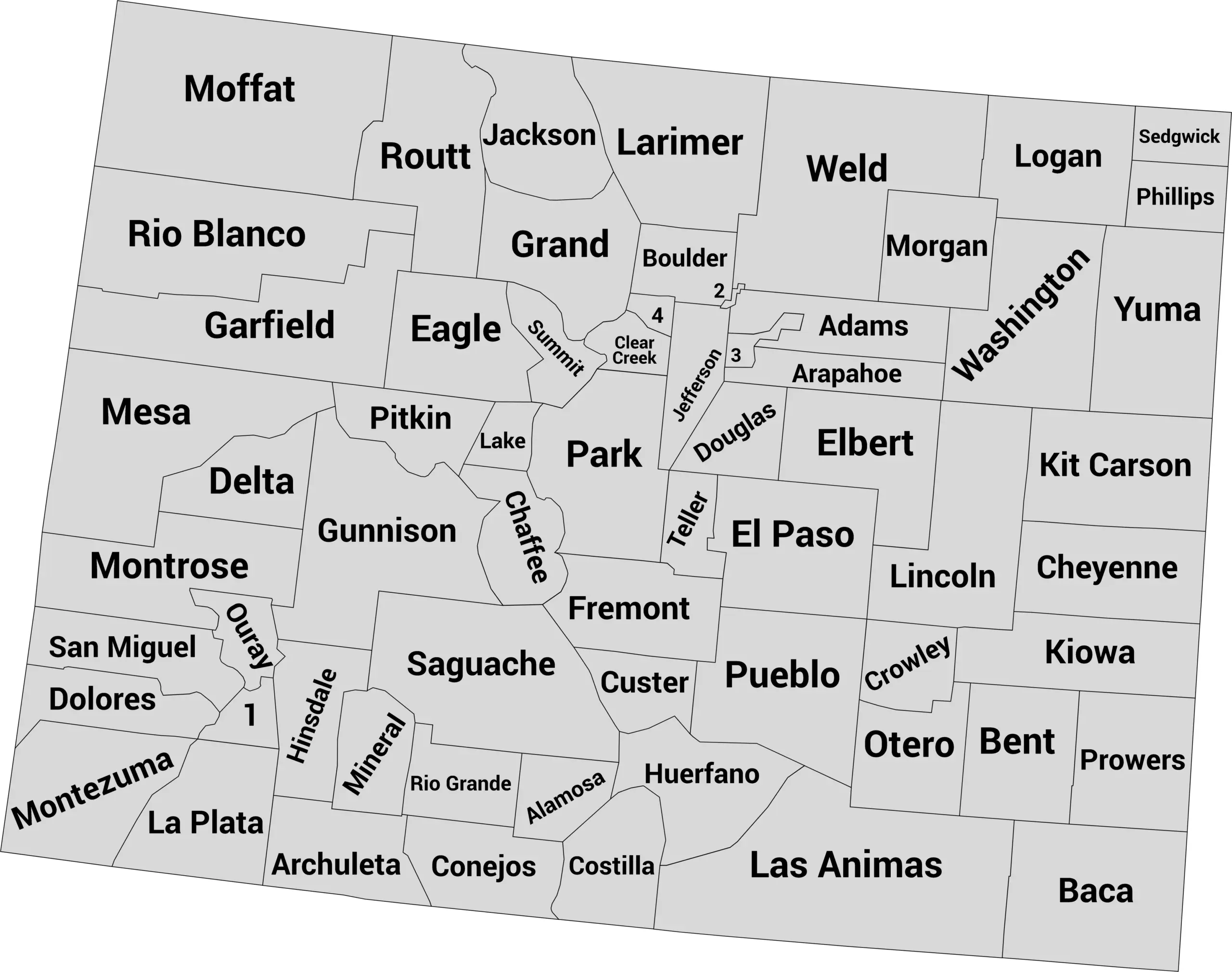
Download Labeled Colorado County Map (WebP)
🌄 Blank Colorado County Map (No Labels)
The blank Colorado county map is perfect for labeling exercises, geography quizzes, or coloring projects.
It provides a clean outline of all county borders — great for schools, educational websites, or printable worksheets.
🖼️ Colorado County Map (without labels):
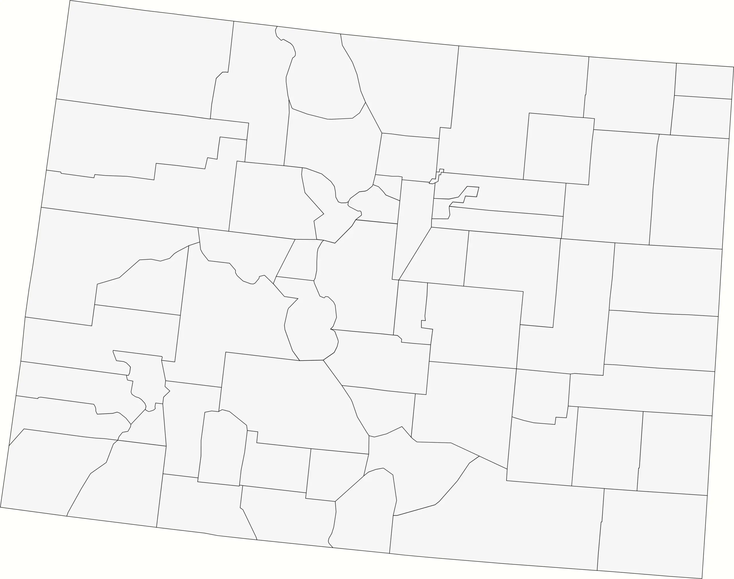
Download Blank Colorado County Map (WebP)
🧭 About Colorado’s Counties
Colorado’s counties stretch from snow-capped peaks to high plains farmland. Here are a few of the most well-known:
- Denver County — The state’s capital and largest metropolitan area.
- El Paso County — Home to Colorado Springs and stunning mountain views.
- Boulder County — Known for its outdoor recreation and vibrant culture.
- Larimer County — Includes Fort Collins and the gateway to Rocky Mountain National Park.
- Mesa County — Features dramatic canyons and high-desert landscapes in western Colorado.
Each county offers a piece of the state’s diverse beauty — from ski towns and national parks to agricultural heartlands.
🧾 Uses for the Colorado County Map
These maps can be used for a variety of purposes, including:
✅ Educational and classroom use
✅ Geography and history lessons
✅ Travel planning and regional research
✅ Data visualization and county-level mapping
✅ Coloring or art projects
📥 Download Colorado County Maps
Get free, printable versions of both maps below:
Both maps are high-quality and suitable for school, personal, or professional projects.
Colorado Counties by Population (2025 estimates)
Colorado has 64 counties spanning from the Rocky Mountains to the Eastern Plains. The table below lists every county with its 2025 estimated population. El Paso County and Denver County are the most populated, while San Juan and Hinsdale are the smallest by population.
| County | Population (2025 est.) |
|---|---|
| El Paso County | 751,453 |
| Denver County | 722,825 |
| Arapahoe County | 655,645 |
| Jefferson County | 577,476 |
| Adams County | 545,077 |
| Douglas County | 393,995 |
| Larimer County | 374,574 |
| Weld County | 369,745 |
| Boulder County | 330,262 |
| Pueblo County | 169,866 |
| Mesa County | 161,260 |
| Broomfield County | 78,323 |
| Garfield County | 64,979 |
| La Plata County | 57,948 |
| Montrose County | 45,532 |
| Eagle County | 55,675 |
| Fremont County | 48,513 |
| Monte Vista County | 16,248 |
| Summit County | 31,068 |
| Routt County | 26,998 |
| Delta County | 31,644 |
| Montezuma County | 26,985 |
| Morgan County | 30,276 |
| Otero County | 18,120 |
| Logan County | 22,004 |
| Alamosa County | 16,666 |
| Chaffee County | 21,781 |
| Park County | 19,240 |
| Gunnison County | 18,359 |
| Archuleta County | 14,071 |
| Rio Blanco County | 6,492 |
| Huerfano County | 6,498 |
| Las Animas County | 13,195 |
| Grand County | 17,394 |
| San Miguel County | 8,070 |
| Lake County | 7,864 |
| Pitkin County | 17,641 |
| Gunnison County | 18,359 |
| Saguache County | 6,994 |
| Custer County | 5,708 |
| Rio Grande County | 11,401 |
| Costilla County | 3,476 |
| Mineral County | 970 |
| Hinsdale County | 753 |
| San Juan County | 794 |
| Ouray County | 5,170 |
| Dolores County | 2,161 |
| Kiowa County | 1,284 |
| Prowers County | 11,809 |
| Baca County | 3,415 |
| Bent County | 5,365 |
| Conejos County | 7,973 |
| Crowley County | 5,219 |
| Cheyenne County | 1,830 |
| Kit Carson County | 7,189 |
| Lincoln County | 5,478 |
| Phillips County | 4,530 |
| Washington County | 4,847 |
| Yuma County | 9,686 |
| Elbert County | 29,382 |
| Gilpin County | 5,963 |
| Clear Creek County | 9,076 |
| Jackson County | 1,392 |
| Dolores County | 2,161 |
| Summit County | 31,068 |
Note: Population figures are 2025 estimates from World Population Review. Official U.S. Census Bureau estimates may vary slightly.
❓ Frequently Asked Questions About Colorado Counties
How many counties are in Colorado?
Colorado has 64 counties in total. These range from densely populated urban counties like Denver and El Paso to remote mountain and plains counties with fewer than 1,000 residents.
What is the largest county in Colorado by population?
El Paso County is the largest by population, home to the city of Colorado Springs and over 750,000 residents.
Which county has the smallest population?
Hinsdale County is the least populated in Colorado, with fewer than 800 residents as of 2025.
What is the largest county by land area?
Las Animas County, located in southern Colorado, covers over 4,700 square miles—making it the largest by land area.
Which counties include major cities?
- Denver County – City and County of Denver
- El Paso County – Colorado Springs
- Arapahoe County – Aurora and Centennial
- Larimer County – Fort Collins
- Boulder County – Boulder and Longmont
What are the newest counties in Colorado?
Broomfield County is Colorado’s newest county, officially created in 2001 when it separated from four surrounding counties (Adams, Boulder, Jefferson, and Weld).
Which counties border other states?
Several counties in Colorado border other U.S. states, including:
- La Plata and Montezuma – border New Mexico
- Yuma, Phillips, and Kit Carson – border Kansas
- Moffat – borders Utah and Wyoming
- Baca – borders Oklahoma and New Mexico
What are the major geographic regions of Colorado?
Colorado’s counties are divided into several distinct regions:
- Front Range – includes Denver, Boulder, and Colorado Springs
- Western Slope – includes Mesa, Garfield, and Montrose counties
- Eastern Plains – agricultural counties like Yuma, Kit Carson, and Logan
- Mountain Region – scenic areas like Summit, Pitkin, and Gunnison counties
Where can I find Colorado county maps?
This post includes both a labeled Colorado county map and a blank outline map for educational and design use. You can download them directly for study, classroom projects, or website use.
Which county is home to the state capital?
Denver County is home to Colorado’s state capital, Denver, located in the heart of the Front Range region.


