🗺️ Iowa County Map (With and Without Labels)
Iowa, located in the heart of the Midwest, is known as the Hawkeye State and is famous for its fertile farmland, rolling hills, and small-town charm. The state is divided into 99 counties, each with its own unique history and landscape.
Below, you’ll find two versions of the Iowa County Map — one with county labels and another blank version without labels. Both are provided in .webp format for fast-loading, high-quality web display.
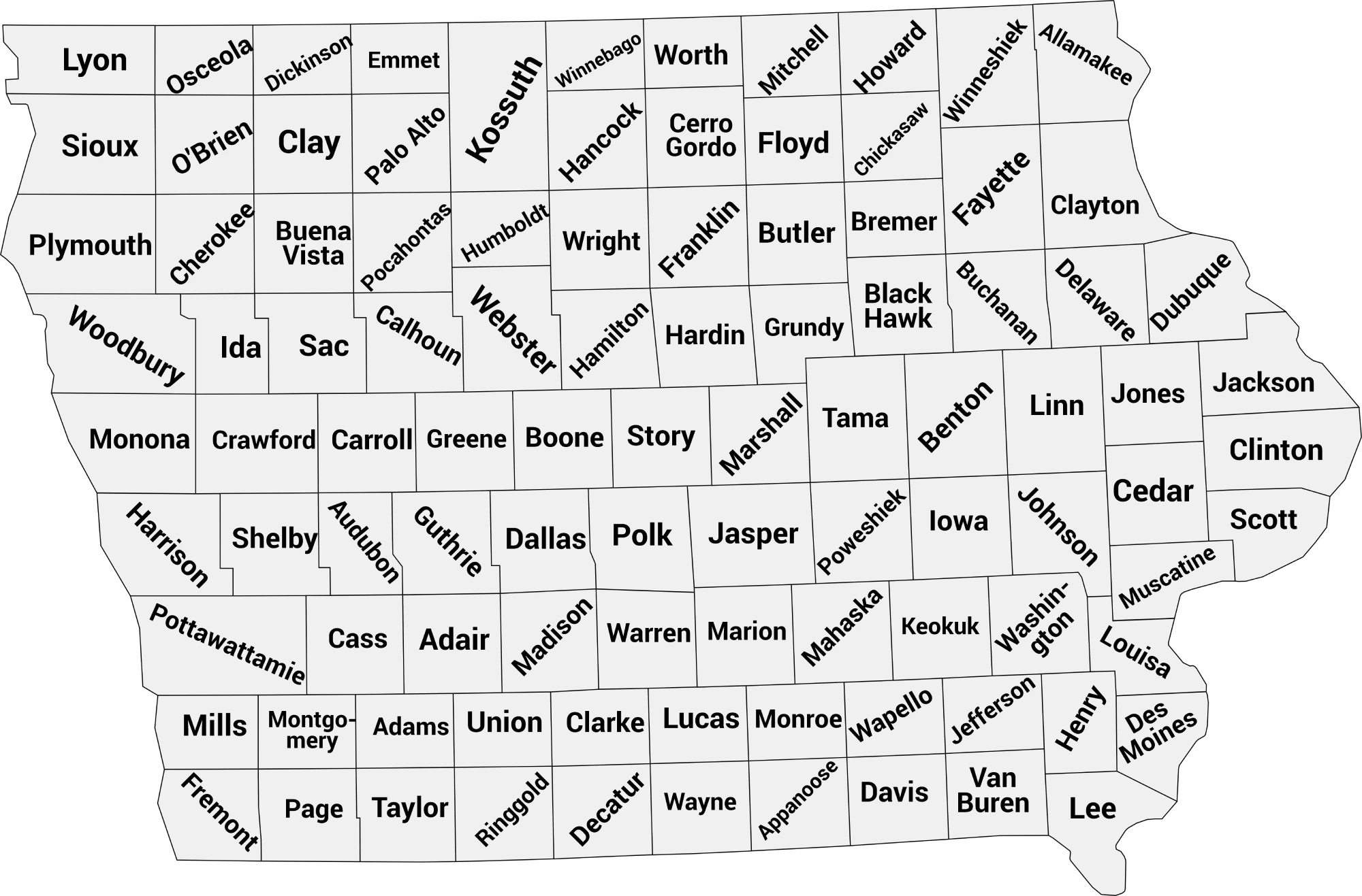
📍 Iowa County Map with Labels
The labeled Iowa county map below clearly shows all 99 counties. This map is perfect for students, educators, or anyone wanting to understand Iowa’s geography.
🖼️ Iowa County Map (with labels):
Download Labeled Iowa County Map (.webp)
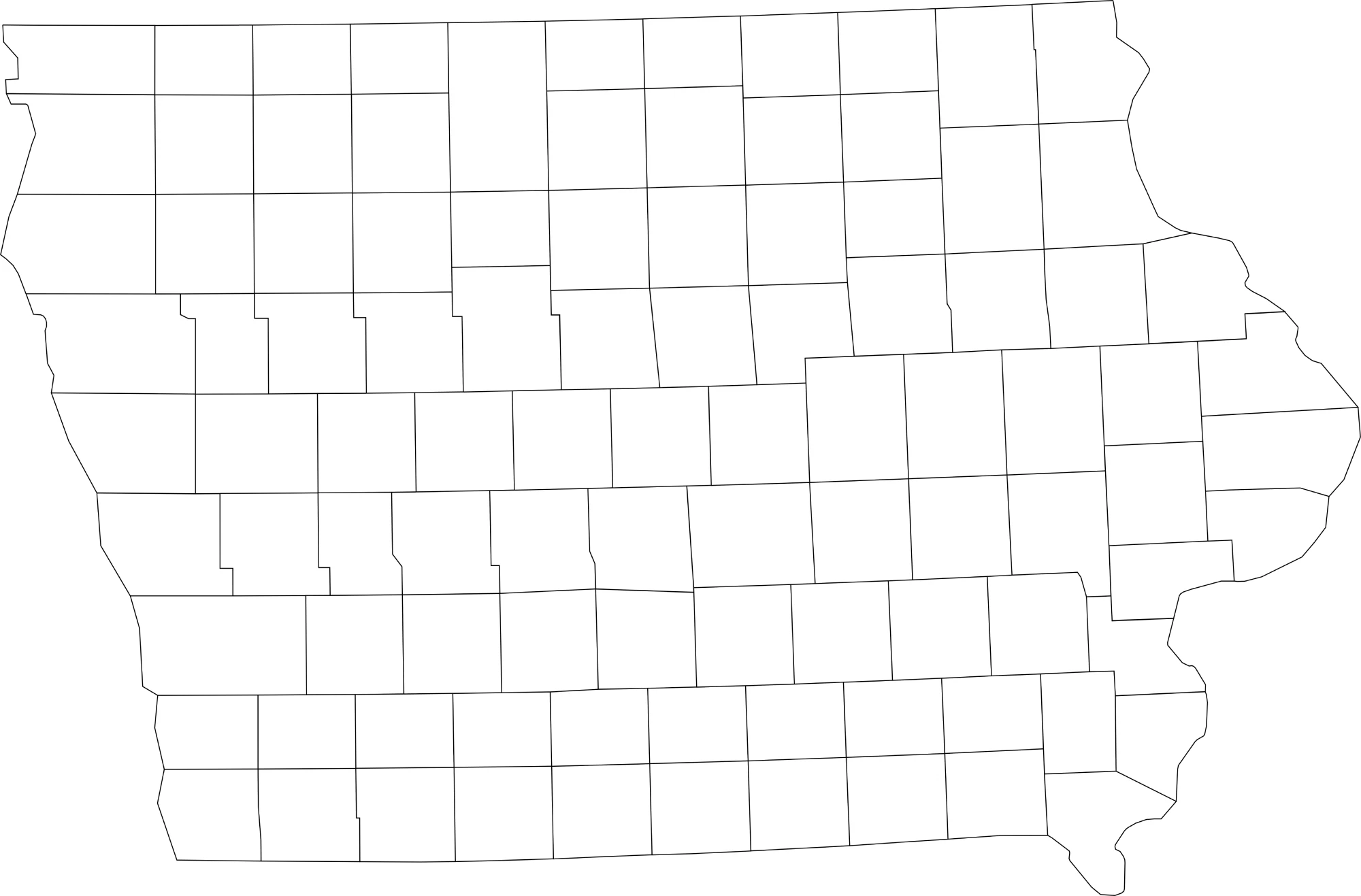
🌄 Blank Iowa County Map (No Labels)
The blank Iowa county map provides a clean outline of all counties without labels. It’s ideal for educational exercises, quizzes, or custom labeling and coloring projects.
🖼️ Iowa County Map (without labels):
Download Blank Iowa County Map (.webp)
🧭 About Iowa’s Counties
Iowa’s counties feature a mix of agricultural, urban, and suburban areas. Here are a few notable counties:
- Polk County — Home to Des Moines, the state capital and largest city.
- Linn County — Includes Cedar Rapids, a major economic and cultural hub.
- Scott County — Part of the Quad Cities region along the Mississippi River.
- Johnson County — Contains Iowa City and the University of Iowa.
- Story County — Home to Ames and Iowa State University.
These counties highlight Iowa’s combination of farmland, small cities, and educational and cultural centers.
🧾 Uses for the Iowa County Map
These maps are ideal for:
✅ Classroom and educational activities
✅ Geography quizzes and labeling exercises
✅ Travel or regional planning
✅ Data visualization and county-level research
✅ Coloring and creative projects
📥 Download Iowa County Maps
You can download high-quality .webp versions of both maps:
Both maps are printable, fast-loading for web, and perfect for educational, personal, or professional use.
📊 Iowa Counties by Estimated Population (2025 / Latest Available)
Iowa has 99 counties, and below is a full HTML table with the most recent 2024–2025 population estimates based on the latest U.S. Census Bureau data and population estimate sources. The list below is sorted from the most to least populous and reflects the latest available population data for every Iowa county.
| County | Estimated Population |
|---|---|
| Polk County | 516,185 |
| Linn County | 231,762 |
| Scott County | 175,601 |
| Johnson County | 160,080 |
| Black Hawk County | 132,348 |
| Dallas County | 115,343 |
| Woodbury County | 107,257 |
| Story County | 102,498 |
| Dubuque County | 99,242 |
| Pottawattamie County | 93,529 |
| Warren County | 56,343 |
| Clinton County | 46,015 |
| Cerro Gordo County | 42,493 |
| Muscatine County | 42,132 |
| Marshall County | 40,392 |
| Des Moines County | 38,411 |
| Jasper County | 38,107 |
| Webster County | 36,909 |
| Sioux County | 36,554 |
| Wapello County | 35,681 |
| Marion County | 34,048 |
| Lee County | 32,376 |
| Boone County | 26,729 |
| Plymouth County | 25,825 |
| Benton County | 25,799 |
| Bremer County | 25,328 |
| Washington County | 22,631 |
| Mahaska County | 22,034 |
| Jones County | 21,116 |
| Buena Vista County | 20,816 |
| Buchanan County | 20,733 |
| Carroll County | 20,407 |
| Winneshiek County | 19,723 |
| Jackson County | 19,390 |
| Henry County | 19,361 |
| Fayette County | 19,152 |
| Poweshiek County | 18,454 |
| Cedar County | 18,231 |
| Dickinson County | 18,158 |
| Delaware County | 17,609 |
| Madison County | 17,161 |
| Clayton County | 16,931 |
| Tama County | 16,738 |
| Clay County | 16,474 |
| Hardin County | 16,464 |
| Iowa County | 16,423 |
| Crawford County | 16,378 |
| Jefferson County | 15,781 |
| Page County | 15,038 |
| Floyd County | 15,008 |
| Hamilton County | 14,856 |
| Mills County | 14,717 |
| Harrison County | 14,626 |
| Kossuth County | 14,408 |
| O’Brien County | 14,260 |
| Allamakee County | 14,184 |
| Butler County | 14,156 |
| Cass County | 13,024 |
| Wright County | 12,729 |
| Grundy County | 12,405 |
| Lyon County | 12,378 |
| Appanoose County | 12,106 |
| Union County | 11,955 |
| Shelby County | 11,821 |
| Chickasaw County | 11,719 |
| Cherokee County | 11,658 |
| Guthrie County | 10,774 |
| Mitchell County | 10,632 |
| Louisa County | 10,630 |
| Hancock County | 10,616 |
| Winnebago County | 10,383 |
| Montgomery County | 10,063 |
| Franklin County | 10,024 |
| Keokuk County | 9,855 |
| Calhoun County | 9,711 |
| Humboldt County | 9,617 |
| Sac County | 9,533 |
| Clarke County | 9,524 |
| Howard County | 9,360 |
| Davis County | 9,193 |
| Emmet County | 9,162 |
| Palo Alto County | 8,809 |
| Lucas County | 8,758 |
| Greene County | 8,662 |
| Monona County | 8,429 |
| Decatur County | 7,656 |
| Adair County | 7,431 |
| Monroe County | 7,373 |
| Worth County | 7,307 |
| Van Buren County | 7,217 |
| Pocahontas County | 7,006 |
| Ida County | 6,810 |
| Wayne County | 6,622 |
| Fremont County | 6,494 |
| Osceola County | 6,036 |
| Taylor County | 5,825 |
| Audubon County | 5,562 |
| Ringgold County | 4,608 |
| Adams County | 3,606 |
🧠 Frequently Asked Questions About the Iowa County Map
How many counties are in Iowa?
Iowa has 99 counties, each serving as a local government unit within the state.
Which is the largest county by population?
Polk County is the most populous county in Iowa, home to Des Moines, the state capital, with over 500,000 residents.
Which county is the largest by land area?
Kossuth County is the largest county by land area in Iowa, covering a significant portion of northern Iowa.
What is the smallest county in Iowa?
Adair County is the smallest county by population, while Decatur County is one of the smallest by land area.
Does Iowa use counties for local government?
Yes. Iowa counties provide essential services including law enforcement, courts, elections, public health, and infrastructure maintenance.
What is the Iowa county map with labels used for?
A labeled county map helps users easily identify county boundaries, major cities, and regional divisions throughout the state.
What is the blank Iowa county map used for?
The blank map is perfect for educational labeling, classroom exercises, quizzes, homeschooling, or custom mapping projects.
Are Iowa counties divided into regions?
Yes. Iowa is often divided into Northern Iowa, Central Iowa, and Southern Iowa, which helps describe geographic and cultural differences.
Why are Iowa counties important for planning and services?
Counties manage local governance, agriculture, public services, and regional planning, supporting both rural and urban communities.
🌎 Explore More Maps
View more nearby state maps:


