🗺️ Kansas County Map (With and Without Labels)
Kansas, known as the Sunflower State, is famous for its wide plains, agriculture, and rich history. The state is divided into 105 counties, each with its own unique geography, communities, and culture.
Below, you’ll find two versions of the Kansas County Map — one with county labels and another blank version without labels. Both maps are provided in .webp format for fast-loading, high-quality display on your website.
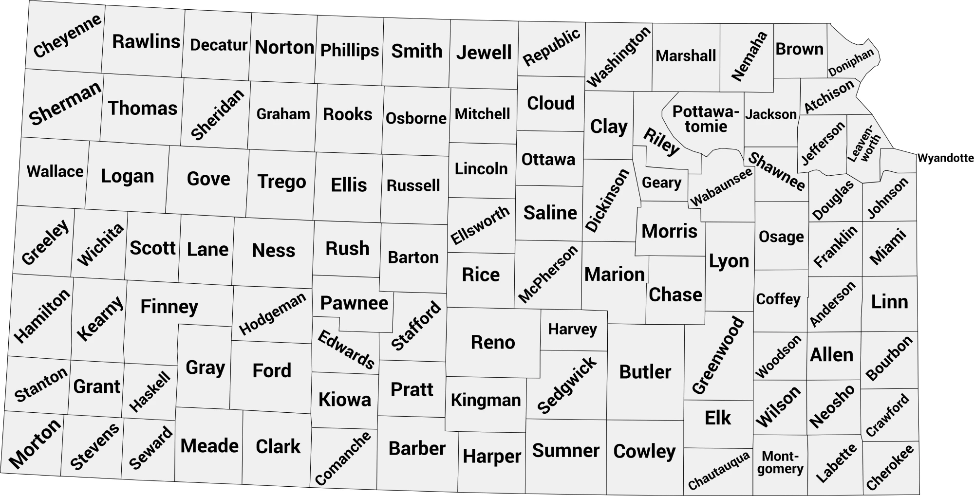
📍 Kansas County Map with Labels
The labeled Kansas county map below clearly marks all 105 counties. This version is ideal for students, teachers, travelers, or anyone studying Kansas geography.
🖼️ Kansas County Map (with labels):
Download Labeled Kansas County Map (.webp)
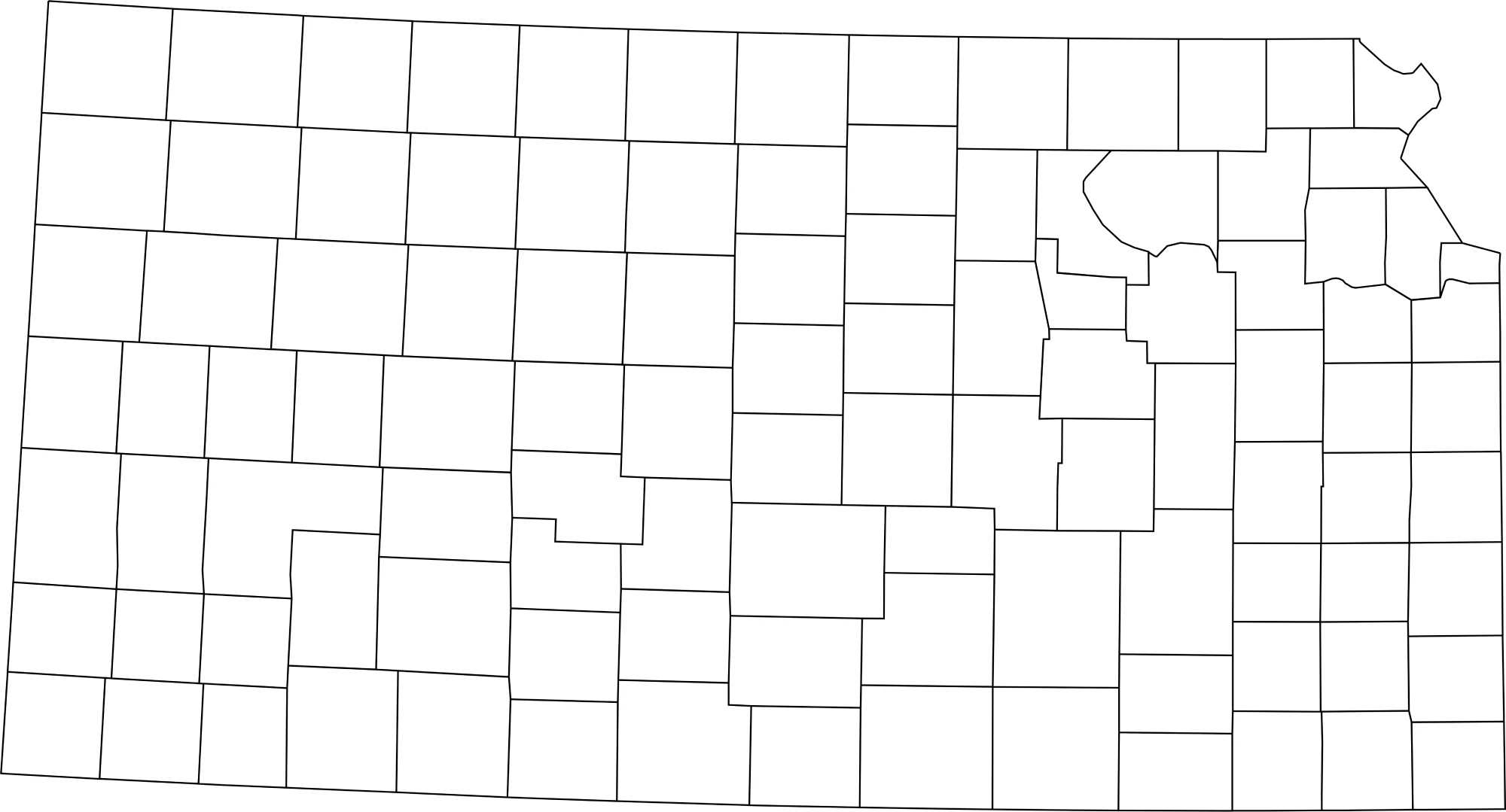
🌄 Blank Kansas County Map (No Labels)
The blank Kansas county map provides a clean outline of all county borders. Perfect for labeling exercises, quizzes, classroom activities, or coloring projects.
🖼️ Kansas County Map (without labels):
🧭 About Kansas’ Counties
Kansas’ counties cover diverse terrain — from agricultural plains to small urban centers. Here are a few notable counties:
- Johnson County — Part of the Kansas City metro area, heavily suburban with strong economic growth.
- Sedgwick County — Includes Wichita, the largest city in Kansas.
- Douglas County — Home to Lawrence and the University of Kansas.
- Shawnee County — Contains Topeka, the state capital.
- Riley County — Includes Manhattan and Kansas State University.
Each county represents a piece of Kansas’ rich agricultural, educational, and cultural landscape.
🧾 Uses for the Kansas County Map
These maps are great for:
✅ Educational projects and classroom activities
✅ Geography quizzes and labeling exercises
✅ Travel or regional research
✅ Data visualization and county-level analysis
✅ Coloring and creative projects
📥 Download Kansas County Maps
Download the high-quality .webp maps below:
Both maps are printable, fast-loading for web, and perfect for educational, personal, or professional use.
📊 Kansas Counties by Estimated Population (2025 / Latest Estimates)
Here’s a complete population table for all 105 counties in Kansas with the most recent available estimates (primarily from 2024–2025 vintage estimates). Kansas has 105 counties in total.
| County | Estimated Population |
|---|---|
| Johnson County | 639,108 |
| Sedgwick County | 541,908 |
| Shawnee County | 178,288 |
| Wyandotte County | 171,904 |
| Douglas County | 122,799 |
| Leavenworth County | 84,114 |
| Riley County | 72,016 |
| Butler County | 68,975 |
| McPherson County | 30,119 |
| Montgomery County | 30,283 |
| Miami County | 35,849 |
| Cowley County | 33,891 |
| Lyon County | 32,313 |
| Crawford County | 38,383 |
| Osage County | 15,943 |
| Jackson County | 13,444 |
| Allen County | 12,335 |
| Atchison County | 15,979 |
| Bourbon County | 14,373 |
| Labette County | 19,754 |
| Cherokee County | 19,083 |
| Neosho County | 15,257 |
| Barton County | 24,740 |
| Sumner County | 22,309 |
| Jefferson County | 18,300 |
| Cloud County | 8,774 |
| Coffey County | 8,250 |
| Clay County | 7,973 |
| Ottawa County | 5,830 |
| Nemaha County | 10,064 |
| Mitchell County | 5,708 |
| Norton County | 5,335 |
| Pawnee County | 6,539 |
| Phillips County | 5,297 |
| Rooks County | 4,985 |
| Russell County | 4,893 |
| Scott County | 4,893 |
| Seward County | 21,209 |
| Rice County | 9,532 |
| Republic County | 4,607 |
| Harvey County | 34,024 |
| Ford County | 33,971 |
| Geary County | 35,586 |
| Finney County | ?? |
| Saline County | 53,098 |
| Pottawatomie County | 26,382 |
| Pratt County | 9,342 |
| Rice County | 9,532 |
| Silver Lake County | ?? |
| Woodson County | 3,113 |
| Meade County | 3,909 |
| Morris County | 5,268 |
| Ness County | 2,579 |
| Neosho County | 15,257 |
| Ness County | 2,579 |
| Norton County | 5,335 |
| Osborne County | 3,373 |
| Rawlins County | 2,549 |
| Smith County | 3,594 |
| Rice County | 9,532 |
| Riley County | 72,016 |
| Rooks County | 4,985 |
| Rush County | 2,953 |
| Russell County | 4,893 |
| Scott County | 4,893 |
| Stafford County | 4,125 |
| Stanton County | 1,835 |
| Sheridan County | 1,613 |
| Gove County | 2,589 |
| Graham County | 2,564 |
| Decatur County | 2,832 |
| Cheyenne County | 2,654 |
| Kearny County | 3,781 |
| Kiowa County | 2,343 |
| Lane County | 1,514 |
| Wallace County | 1,525 |
| Logan County | 2,627 |
| Comanche County | 1,620 |
| Hodgeman County | 1,613 |
| Clark County | 1,755 |
| Stanton County | 1,835 |
| Greeley County | 1,227 |
📌 Notes & Highlights
- Kansas has 105 counties total. Wikipedia
- The most populous county is Johnson County, and other large counties include Sedgwick, Shawnee, Wyandotte, and Douglas. World Population Review
- The least populous counties include Greeley, Lane, Wallace, and Stanton — many with populations under ~2,000.
🧠 Frequently Asked Questions About the Kansas County Map
How many counties are in Kansas?
Kansas has 105 counties, each serving as a local government unit within the state.
Which is the largest county by population?
Johnson County is the most populous county in Kansas, part of the Kansas City metropolitan area, with over 620,000 residents.
Which county is the largest by land area?
Sedgwick County, home to Wichita, is one of the largest counties by population and land area in Kansas, though Butler County is the largest by land area overall.
What is the smallest county in Kansas?
Greeley County is the smallest county by population, while Wyandotte County is the smallest by land area.
Does Kansas use counties for local government?
Yes. Kansas counties provide essential services including law enforcement, courts, elections, public health, and road maintenance.
What is the Kansas county map with labels used for?
A labeled county map helps users identify county boundaries, major cities, and regional divisions throughout the state.
What is the blank Kansas county map used for?
The blank map is perfect for educational labeling, classroom exercises, quizzes, homeschooling, or custom mapping projects.
Are Kansas counties divided into regions?
Yes. Kansas is often divided into Eastern Kansas, Central Kansas, and Western Kansas, which helps describe geographic, economic, and cultural differences.
Why are Kansas counties important for planning and services?
Counties play a key role in local governance, agricultural planning, transportation infrastructure, and emergency services across both rural and urban areas.
🌎 Explore More Maps
View more nearby state maps:


