Minnesota County Map (With and Without Labels)
Minnesota, known as the Land of 10,000 Lakes, is famous for its stunning natural beauty, outdoor recreation, and friendly communities. The state is divided into 87 counties, each offering its own mix of forests, lakes, and vibrant towns.
Below, you’ll find two versions of the Minnesota County Map — one with county labels and another blank version without labels. Both are provided in .webp format for fast-loading, high-quality use on your website.
📍 Minnesota County Map with Labels
The labeled Minnesota county map below displays all 87 counties, making it ideal for teachers, students, travelers, and anyone interested in Minnesota’s geography.
🖼️ Minnesota County Map (with labels):
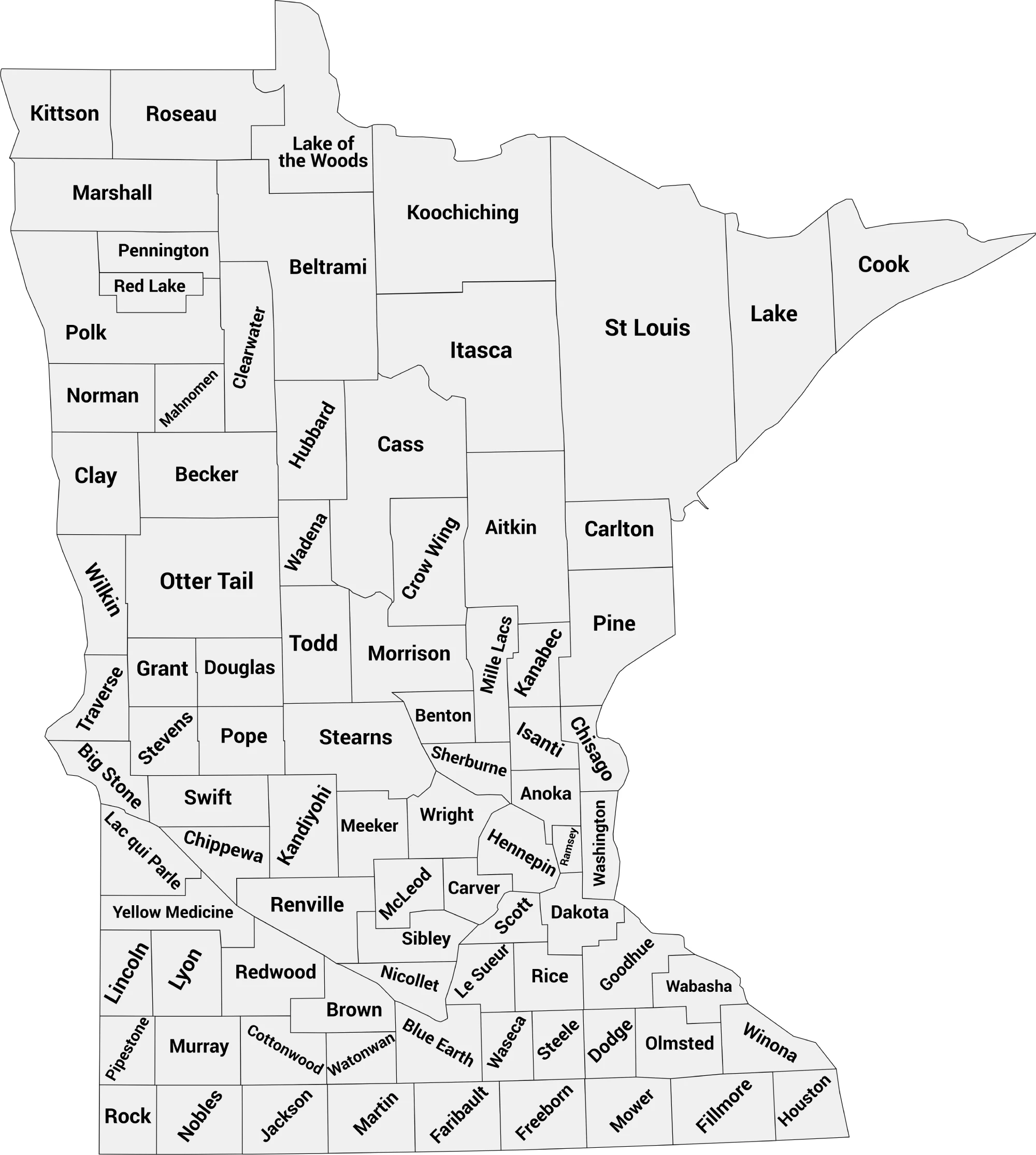
Download Labeled Minnesota County Map (.webp)
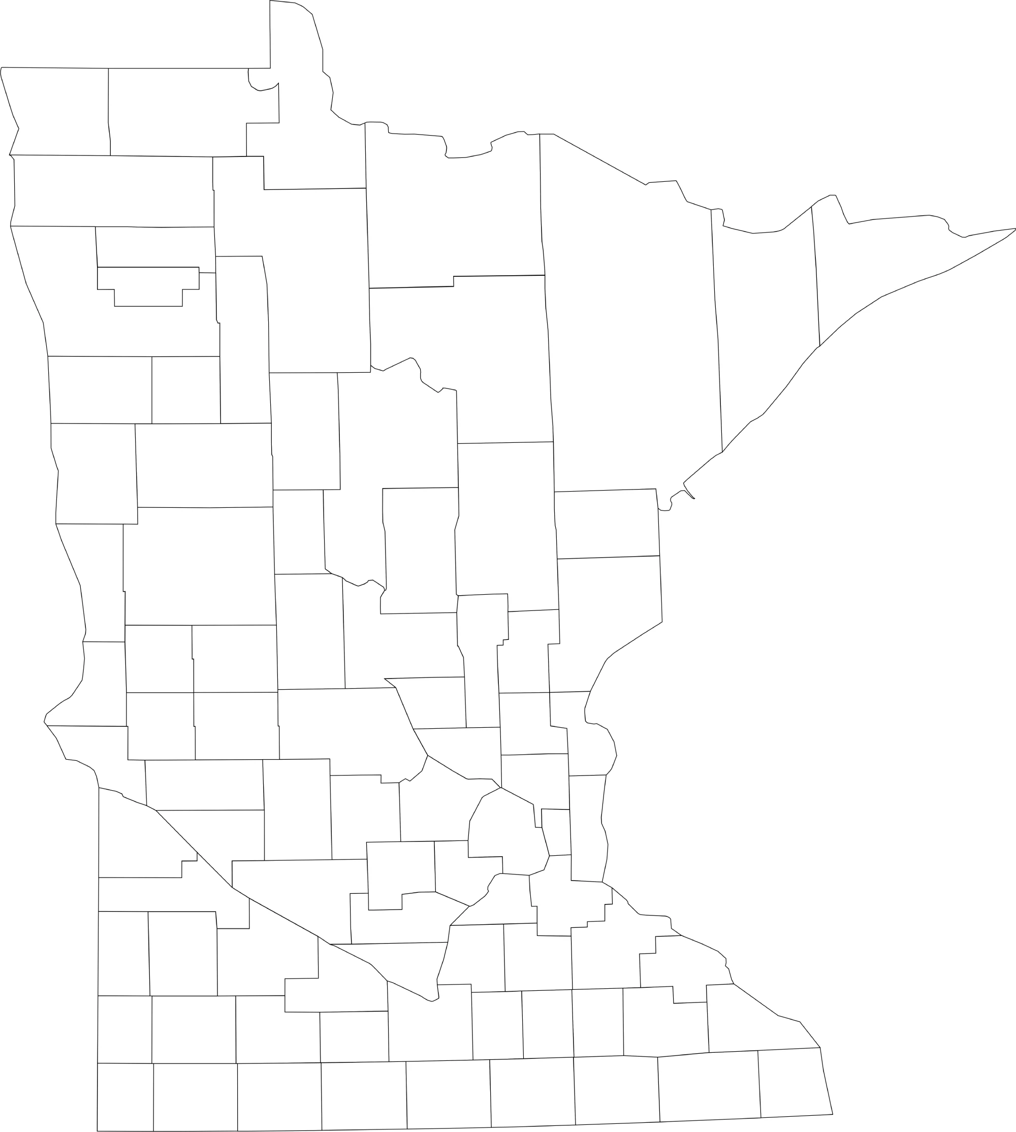
🌄 Blank Minnesota County Map (No Labels)
The blank Minnesota county map provides a clean outline of county boundaries without any names. This version is perfect for classroom use, labeling activities, quizzes, or coloring projects.
🖼️ Minnesota County Map (without labels):
🧭 About Minnesota’s Counties
Minnesota’s counties stretch from the busy Twin Cities area to quiet northern lakes and forest regions. Here are a few of the most notable counties:
- Hennepin County — Home to Minneapolis, the state’s largest city.
- Ramsey County — Includes Saint Paul, Minnesota’s capital.
- St. Louis County — The largest county in Minnesota, known for Duluth and the Boundary Waters.
- Olmsted County — Contains Rochester, home of the Mayo Clinic.
- Stearns County — Features St. Cloud and beautiful central lakes.
Each county contributes to Minnesota’s diverse economy and outdoor lifestyle, from agriculture and health care to tourism and technology.
🧾 Uses for the Minnesota County Map
These maps are great for:
✅ Educational and classroom projects
✅ Geography labeling and coloring activities
✅ Data visualization and regional studies
✅ Travel planning and local research
✅ Printable county reference guides
📥 Download Minnesota County Maps
Download both high-quality .webp maps below:
Both maps are printable, fast-loading, and perfect for educational, research, or creative use.
List of Minnesota Counties with Population
Explore the estimated populations of all 87 counties in Minnesota for the year 2024. This comprehensive list provides insights into the demographic distribution across the state,
| County | Population Estimate (2024) |
|---|---|
| Aitkin | 16,000 |
| Anoka | 374,077 |
| Becker | 35,000 |
| Beltrami | 47,000 |
| Benton | 42,000 |
| Big Stone | 5,000 |
| Blue Earth | 70,000 |
| Brown | 26,000 |
| Carlton | 40,000 |
| Carver | 112,931 |
| Cass | 31,000 |
| Chippewa | 12,000 |
| Chisago | 60,000 |
| Clay | 66,000 |
| Clearwater | 10,000 |
| Cook | 5,000 |
| Cottonwood | 12,000 |
| Crow Wing | 65,000 |
| Dakota | 454,301 |
| Dodge | 14,000 |
| Douglas | 42,000 |
| Faribault | 15,000 |
| Fillmore | 22,000 |
| Freeborn | 30,000 |
| Goodhue | 48,000 |
| Grant | 5,000 |
| Hennepin | 1,304,748 |
| Houston | 20,000 |
| Hubbard | 22,000 |
| Isanti | 43,000 |
| Itasca | 65,000 |
| Jackson | 10,000 |
| Kanabec | 16,000 |
| Kandiyohi | 43,000 |
| Kittson | 4,000 |
| Koochiching | 12,000 |
| Lac qui Parle | 7,000 |
| Lake | 10,000 |
| Lake of the Woods | 4,000 |
| Le Sueur | 28,000 |
| Lincoln | 5,000 |
| Lyon | 26,000 |
| McLeod | 40,000 |
| Mahnomen | 5,000 |
| Marshall | 10,000 |
| Martin | 20,000 |
| Meeker | 23,000 |
| Mille Lacs | 28,000 |
| Morristown | 5,000 |
| Mower | 40,000 |
| Murphy | 5,000 |
| Norman | 6,000 |
| Olmsted | 166,280 |
| Otter Tail | 59,000 |
| Pine | 29,000 |
| Pipestone | 9,000 |
| Polk | 32,000 |
| Ramsey | 557,518 |
| Red Lake | 5,000 |
| Redwood | 15,000 |
| Renville | 15,000 |
| Rice | 68,000 |
| Rock | 10,000 |
| Roseau | 16,000 |
| Scott | 158,596 |
| Sibley | 15,000 |
| St. Louis | 202,426 |
| Stearns | 162,447 |
| Steele | 38,000 |
| Swift | 9,000 |
| Todd | 25,000 |
| Traverse | 3,000 |
| Wabasha | 22,000 |
| Wadena | 13,000 |
| Washington | 285,550 |
| Watonwan | 11,000 |
| Wilkin | 6,000 |
| Winona | 51,000 |
| Wright | 157,214 |
| Yellow Medicine | 10,000 |
🧠 Frequently Asked Questions About the Minnesota County Map
How many counties are in Minnesota?
Minnesota has 87 counties, each serving as a unit of local government across the state.
Which is the largest county by population?
Hennepin County is the most populous county in Minnesota and includes much of Minneapolis, with over 1.2 million residents.
Which county is the largest by land area?
St. Louis County is the largest county by land area in Minnesota and one of the largest counties in the United States.
What is the smallest county in Minnesota?
Traverse County is the smallest county by population, while Ramsey County is the smallest by land area.
Does Minnesota use counties for local government?
Yes. Minnesota counties provide essential services such as law enforcement, courts, public health, elections, and social services.
What is the Minnesota county map with labels used for?
A labeled county map helps users identify county boundaries, major cities, and regional divisions across the state.
What is the blank Minnesota county map used for?
The blank map is ideal for educational labeling, classroom activities, quizzes, homeschooling, and custom mapping projects.
Are Minnesota counties divided into regions?
Yes. Minnesota is often divided into regions such as Twin Cities Metro, Northern Minnesota, Central Minnesota, Southern Minnesota, and the Arrowhead Region.
Why are Minnesota counties important for planning and services?
Counties play a key role in managing transportation networks, healthcare services, land use planning, and economic development across both urban and rural areas.
🌎 Explore More Maps
View more nearby state maps:


