🗺️ Missouri County Map (With and Without Names)
Missouri, known as the Show-Me State, sits in the heart of the Midwest and is known for its mix of rolling hills, river valleys, and cultural landmarks. The state is divided into 114 counties plus the independent City of St. Louis, each with its own unique communities and landscapes.
Below, you’ll find two versions of the Missouri County Map — one with county labels and another blank version without labels. Both maps are provided in .webp format for fast-loading, high-quality use on your website.
📍 Missouri County Map with Labels
The labeled Missouri county map below shows all 114 counties (and St. Louis City), making it ideal for students, teachers, researchers, and travelers exploring Missouri’s regions.
🖼️ Missouri County Map (with labels):
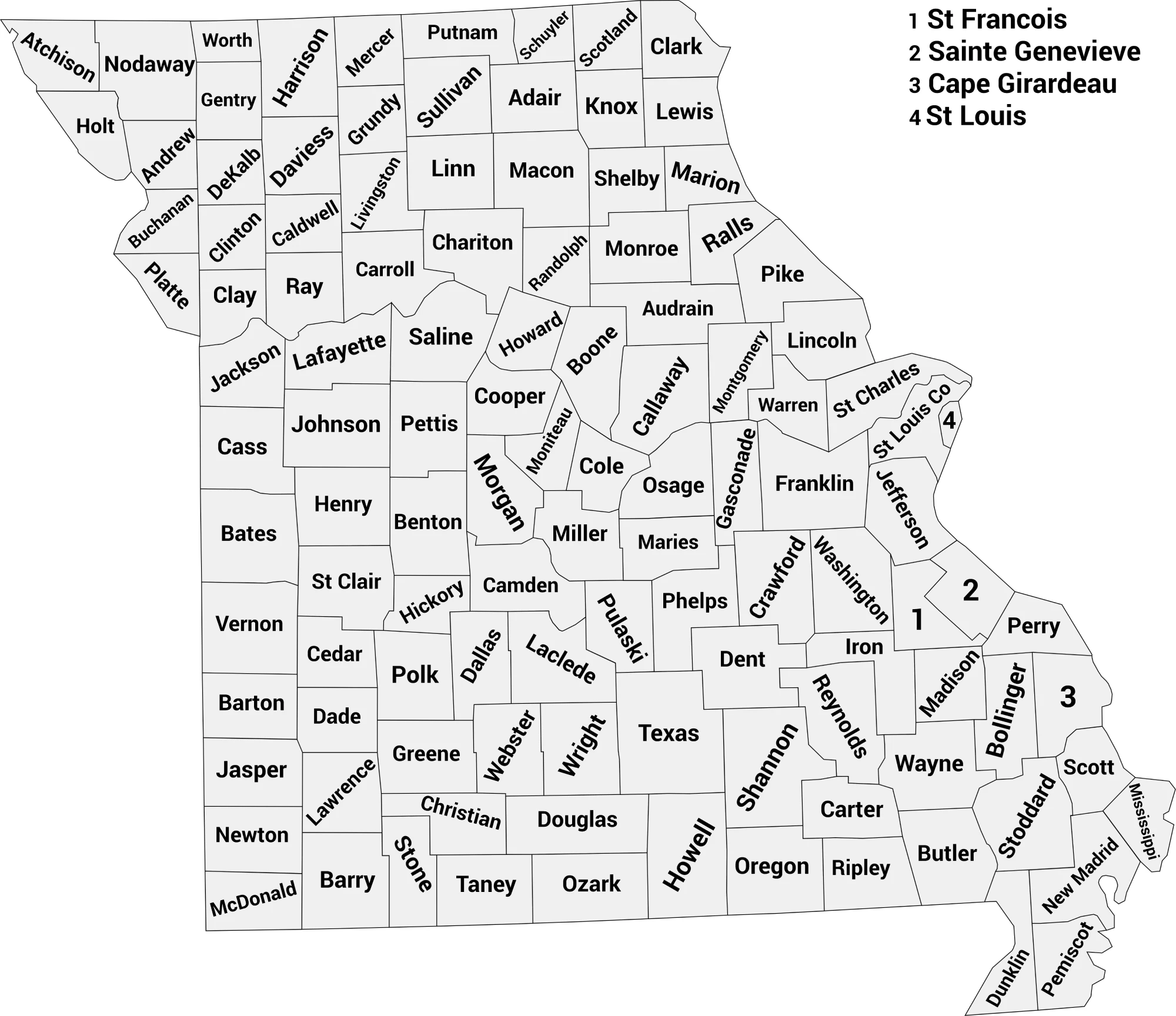
Download Labeled Missouri County Map (.webp)
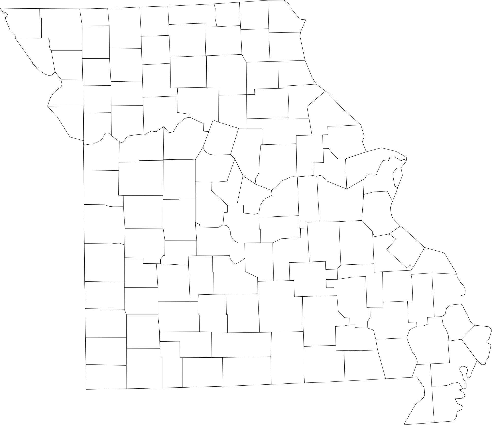
🌄 Blank Missouri County Map (No Labels)
The blank Missouri county map provides a clean outline of the state’s counties without any names. It’s great for geography exercises, labeling activities, quizzes, and classroom use.
🖼️ Missouri County Map (without labels):
🧭 About Missouri’s Counties
Missouri’s counties reflect a balance of urban, rural, and natural environments. From major cities to farmlands and forests, each region has something special to offer.
Here are a few of the most notable counties:
- St. Louis County — The most populous county, surrounding the independent city of St. Louis.
- Jackson County — Home to Kansas City and part of the greater metro area.
- Greene County — Includes Springfield, known for its universities and growing economy.
- Boone County — Location of Columbia and the University of Missouri.
- Cole County — Contains Jefferson City, the state capital.
Each county helps shape Missouri’s history, economy, and culture, from the Ozark Mountains to the Mississippi River.
🧾 Uses for the Missouri County Map
These maps are perfect for:
✅ Geography lessons and educational projects
✅ Classroom labeling and coloring activities
✅ Travel and regional research
✅ Data visualization and reports
✅ County boundary reference for design or study
📥 Download Missouri County Maps
You can download high-quality .webp versions of both maps below:
Both maps are printable, lightweight, and optimized for online and classroom use.
📊 Missouri Counties by Estimated Population (2025 / Latest Estimates)
Here’s a full list of all 115 Missouri county-equivalents (114 counties plus the independent City of St. Louis) with the most recent population estimates available for 2025 from World Population Review’s U.S. county data.
| County | Estimated Population |
|---|---|
| Adair County | 25,000 |
| Andrew County | 18,000 |
| Atchison County | 5,200 |
| Audrain County | 25,500 |
| Barry County | 34,000 |
| Barton County | 11,800 |
| Bates County | 16,000 |
| Benton County | 20,500 |
| Bollinger County | 12,000 |
| Boone County | 189,000 |
| Buchanan County | 85,000 |
| Butler County | 41,000 |
| Caldwell County | 8,700 |
| Callaway County | 46,000 |
| Camden County | 45,500 |
| Cape Girardeau County | 81,000 |
| Carroll County | 9,200 |
| Carter County | 6,000 |
| Cass County | 109,000 |
| Cedar County | 14,000 |
| Chariton County | 7,300 |
| Christian County | 92,000 |
| Clark County | 6,700 |
| Clay County | 255,000 |
| Clinton County | 20,000 |
| Cole County | 78,000 |
| Cooper County | 18,500 |
| Crawford County | 23,500 |
| Dade County | 7,500 |
| Dallas County | 17,000 |
| Daviess County | 8,300 |
| DeKalb County | 12,000 |
| Dent County | 15,500 |
| Douglas County | 13,500 |
| Dunklin County | 29,000 |
| Franklin County | 104,000 |
| Gasconade County | 15,000 |
| Gentry County | 6,500 |
| Greene County | 302,000 |
| Grundy County | 9,800 |
| Harrison County | 8,200 |
| Henry County | 22,000 |
| Hickory County | 9,500 |
| Holt County | 4,300 |
| Howard County | 10,000 |
| Howell County | 40,000 |
| Iron County | 10,000 |
| Jackson County | 706,000 |
| Jasper County | 123,000 |
| Jefferson County | 233,000 |
| Johnson County | 55,000 |
| Knox County | 4,000 |
| Laclede County | 36,000 |
| Lafayette County | 32,000 |
| Lawrence County | 38,000 |
| Lewis County | 10,000 |
| Lincoln County | 61,000 |
| Linn County | 11,800 |
| Livingston County | 14,500 |
| Macon County | 15,000 |
| Madison County | 12,000 |
| Maries County | 8,800 |
| Marion County | 28,000 |
| McDonald County | 23,000 |
| Mercer County | 3,600 |
| Miller County | 26,000 |
| Mississippi County | 13,500 |
| Moniteau County | 16,500 |
| Monroe County | 8,600 |
| Montgomery County | 11,500 |
| Morgan County | 21,000 |
| New Madrid County | 16,500 |
| Newton County | 58,000 |
| Nodaway County | 22,000 |
| Oregon County | 10,500 |
| Osage County | 13,500 |
| Ozark County | 9,200 |
| Pemiscot County | 15,000 |
| Perry County | 19,000 |
| Pettis County | 42,000 |
| Phelps County | 45,000 |
| Pike County | 18,500 |
| Platte County | 111,000 |
| Polk County | 32,000 |
| Pulaski County | 52,000 |
| Putnam County | 4,700 |
| Ralls County | 10,500 |
| Randolph County | 24,000 |
| Ray County | 23,000 |
| Reynolds County | 6,600 |
| Ripley County | 11,000 |
| Saline County | 23,000 |
| Schuyler County | 4,000 |
| Scotland County | 4,800 |
| Scott County | 39,000 |
| Shannon County | 8,000 |
| Shelby County | 6,000 |
| St. Charles County | 410,000 |
| St. Clair County | 9,500 |
| St. Francois County | 66,000 |
| St. Louis County | 990,000 |
| Ste. Genevieve County | 18,500 |
| Stoddard County | 28,000 |
| Stone County | 33,000 |
| Sullivan County | 6,300 |
| Taney County | 57,000 |
| Texas County | 25,000 |
| Vernon County | 20,000 |
| Warren County | 37,000 |
| Washington County | 24,000 |
| Wayne County | 12,000 |
| Webster County | 39,000 |
| Worth County | 2,100 |
| Wright County | 18,500 |
| City of St. Louis | 286,000 |
🧠 Frequently Asked Questions About the Missouri County Map
How many counties are in Missouri?
Missouri has 114 counties, along with the independent city of St. Louis, which is not part of any county.
Which is the largest county by population?
St. Louis County is the most populous county in Missouri, with over 990,000 residents. Jackson County, home to Kansas City, is a close second.
Which county is the largest by land area?
Texas County is the largest county by land area in Missouri, located in the south-central part of the state.
What is the smallest county in Missouri?
Worth County is the smallest county by population, while St. Louis City is the smallest by land area but operates independently from counties.
Does Missouri use counties for local government?
Yes. Missouri counties provide essential services such as law enforcement, courts, elections, road maintenance, and public records.
What is the Missouri county map with labels used for?
A labeled county map helps users identify county boundaries, major cities, and regional divisions across Missouri.
What is the blank Missouri county map used for?
The blank map is ideal for educational labeling, classroom activities, quizzes, homeschooling, or custom mapping projects.
Are Missouri counties divided into regions?
Yes. Missouri is often divided into regions such as Northern Missouri, Central Missouri, Southern Missouri, the Ozarks, and the St. Louis and Kansas City metro areas.
Why are Missouri counties important for government and planning?
Counties manage local governance, transportation networks, agricultural regions, and urban development, supporting both rural communities and major metropolitan areas.
🌎 Explore More Maps
View more nearby state maps:


