🗺️ Montana County Map (With and Without Labels)
Montana, known as the Big Sky Country, is famous for its vast landscapes, mountains, and wide-open spaces. The state is divided into 56 counties, each with its own mix of natural beauty, small towns, and outdoor recreation opportunities.
Below, you’ll find two versions of the Montana County Map — one with county labels and another blank version without labels. Both maps are provided in .webp format for fast-loading, high-quality display on your website.
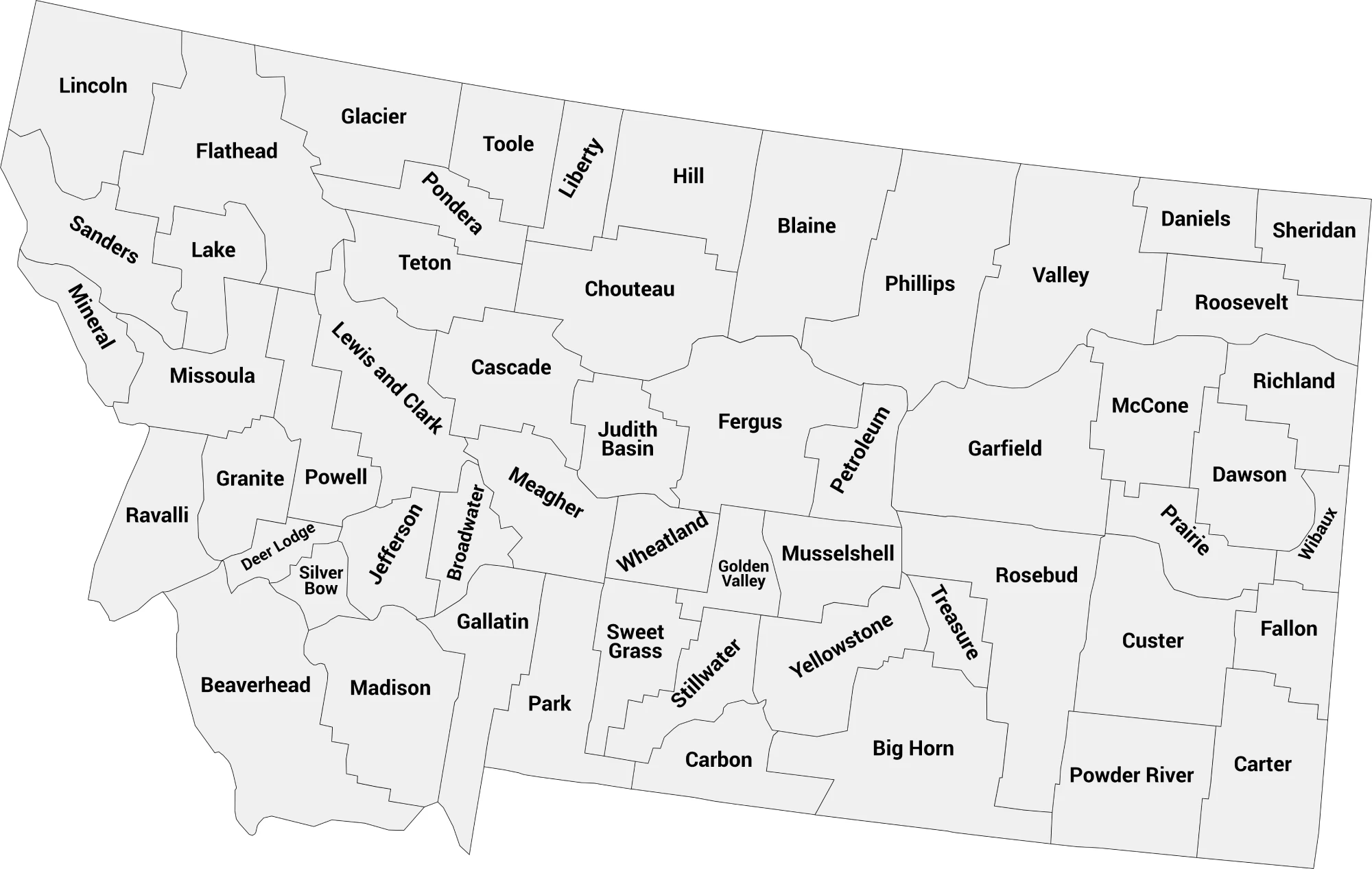
📍 Montana County Map with Labels
The labeled Montana county map clearly shows all 56 counties, making it perfect for students, educators, travelers, or anyone studying Montana’s geography.
🖼️ Montana County Map (with labels):
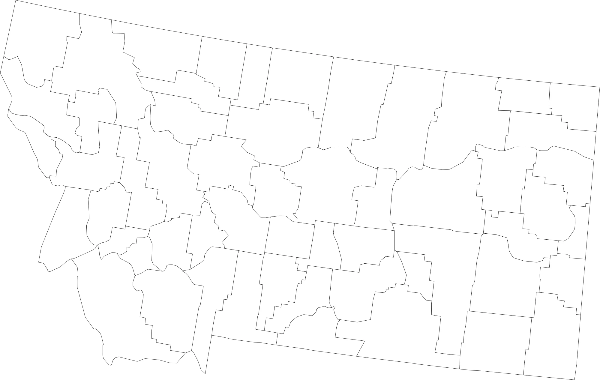
🌄 Blank Montana County Map (No Labels)
The blank Montana county map provides a simple outline of all counties without labels. It’s ideal for classroom exercises, labeling activities, or creative projects.
🖼️ Montana County Map (without labels):
🧭 About Montana’s Counties
Montana’s counties include both rugged mountain areas and expansive plains. Here are a few notable counties:
- Yellowstone County — Home to Billings, the largest city in Montana.
- Missoula County — Contains Missoula, known for its university and cultural events.
- Gallatin County — Includes Bozeman, a hub for outdoor recreation and Montana State University.
- Flathead County — Famous for Glacier National Park and outdoor tourism.
- Cascade County — Includes Great Falls, an important economic and cultural center.
Each county showcases Montana’s vast geography, from the Rocky Mountains to the Great Plains.
🧾 Uses for the Montana County Map
These maps are perfect for:
✅ Educational lessons and classroom projects
✅ Geography quizzes and labeling exercises
✅ Travel planning and regional research
✅ Data visualization and county-level analysis
✅ Coloring and creative projects
📥 Download Montana County Maps
Download high-quality .webp versions of both maps:
Both maps are printable, fast-loading, and perfect for educational, personal, or professional use.
Montana Counties by Population (2025 estimates)
Below is a full list of all 56 counties in Montana with their 2025 estimated populations. Montana’s population is concentrated in counties like Yellowstone, Gallatin, Missoula, and Flathead, while several rural counties have populations under 1,000.
| County | Population (2025 est.) |
|---|---|
| Yellowstone County | 172,789 |
| Gallatin County | 129,351 |
| Missoula County | 123,525 |
| Flathead County | 117,267 |
| Cascade County | 84,698 |
| Lewis and Clark County | 77,465 |
| Ravalli County | 48,860 |
| Silver Bow County | 37,186 |
| Lake County | 34,308 |
| Lincoln County | 22,665 |
| Park County | 18,203 |
| Hill County | 16,592 |
| Sanders County | 14,284 |
| Glacier County | 13,527 |
| Jefferson County | 13,482 |
| Big Horn County | 12,601 |
| Fergus County | 11,972 |
| Custer County | 11,955 |
| Carbon County | 11,785 |
| Richland County | 11,059 |
| Beaverhead County | 10,161 |
| Madison County | 10,059 |
| Deer Lodge County | 9,931 |
| Roosevelt County | 9,883 |
| Stillwater County | 9,181 |
| Dawson County | 8,816 |
| Broadwater County | 8,554 |
| Rosebud County | 8,176 |
| Valley County | 7,338 |
| Powell County | 7,243 |
| Blaine County | 6,753 |
| Teton County | 6,598 |
| Pondera County | 6,191 |
| Chouteau County | 5,725 |
| Musselshell County | 5,586 |
| Toole County | 5,245 |
| Mineral County | 5,230 |
| Phillips County | 4,291 |
| Sweet Grass County | 3,835 |
| Granite County | 3,791 |
| Sheridan County | 3,384 |
| Fallon County | 2,882 |
| Meagher County | 2,161 |
| Judith Basin County | 2,121 |
| Wheatland County | 2,095 |
| Liberty County | 1,974 |
| Powder River County | 1,765 |
| Daniels County | 1,609 |
| McCone County | 1,606 |
| Carter County | 1,448 |
| Garfield County | 1,197 |
| Prairie County | 1,120 |
| Wibaux County | 876 |
| Golden Valley County | 853 |
| Treasure County | 808 |
| Petroleum County | 620 |
Notes: Population figures are 2025 estimates from World Population Review.
FAQs About Montana Counties and Population
How many counties are in Montana?
Montana has a total of 56 counties, each with its own unique history, landscape, and population size. From bustling Yellowstone County to the quiet plains of Petroleum County, Montana’s counties showcase the state’s vast diversity.
Which is the most populous county in Montana?
Yellowstone County is the most populous county in Montana, with an estimated population of over 172,000 people. Billings, the state’s largest city, is located in Yellowstone County.
What is the least populated county in Montana?
Petroleum County has the smallest population in Montana, with fewer than 700 residents. It’s one of the least populated counties in the entire United States.
Which Montana counties are growing the fastest?
Gallatin County and Flathead County are among the fastest-growing in Montana, driven by tourism, outdoor recreation, and an influx of new residents attracted to Bozeman and Kalispell.
Where is Montana’s capital located?
Montana’s state capital is Helena, which is located in Lewis and Clark County. The county has a population of about 77,000 people.
What are the largest cities in Montana by population?
The largest cities in Montana include Billings, Missoula, Great Falls, Bozeman, and Butte. These urban centers are located across the state in counties that also lead in population growth.
Is there a map of Montana counties with labels?
Yes! You can view a detailed Montana county map with labels showing each county’s borders and names. It’s a helpful resource for students, travelers, and anyone learning about Montana geography.
Can I download a blank Montana county outline map?
Absolutely. A blank Montana county outline map is available for download, perfect for educational activities, quizzes, or creating custom regional maps. It shows all county borders without names or labels.
Which counties are popular for outdoor recreation?
Gallatin, Flathead, Park, and Ravalli counties are top destinations for outdoor recreation, offering access to Yellowstone and Glacier National Parks, world-class fishing, hiking, and skiing.
What region of the U.S. is Montana in?
Montana is part of the Mountain West region of the United States. It shares borders with North Dakota, South Dakota, Wyoming, and Idaho, as well as the Canadian provinces of Alberta, British Columbia, and Saskatchewan.


