🗺️ Alabama County Maps – Download a Printable, Detailed County Map of Alabama
If you’re looking for a high-quality Alabama County Map, you’ve come to the right place. Whether you’re a teacher, traveler, student, or researcher, this detailed map of Alabama’s 67 counties will help you explore and understand the Heart of Dixie in a whole new way.
📍 Overview of Alabama’s Counties
Alabama is divided into 67 counties, each with its own unique history, geography, and community identity. From the rolling hills of Madison County in the north to the coastal charm of Mobile County in the south, every county contributes to Alabama’s diverse culture and landscape.
Some of the most notable counties include:
- Jefferson County – Home to Birmingham, the state’s largest city
- Mobile County – Located on the Gulf Coast, known for beaches and Mardi Gras traditions
- Madison County – Site of Huntsville and the U.S. Space & Rocket Center
- Montgomery County – The state capital and a major hub for history and government
🗺️ Alabama County Map with County Labels (Downloadable)
Below is a detailed Alabama County Map showing all county boundaries
👉 Download Alabama County Map
(Print-friendly and perfect for classrooms, reports, or travel planning.)
You can also view the map directly below:
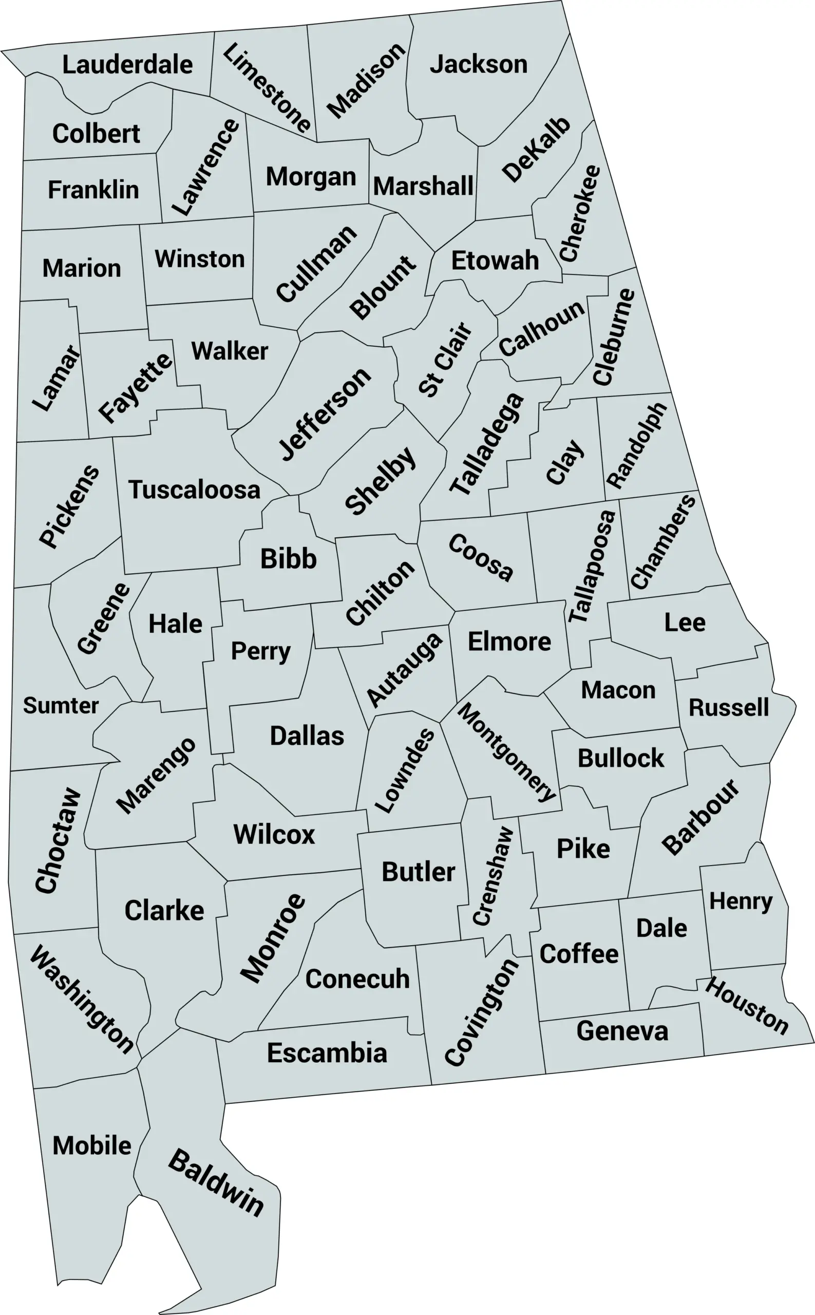
Blank Alabama County Map

🧭 Uses for the Alabama County Map
This map is great for:
- Education: Teaching Alabama geography in schools
- Research: Understanding demographic or political boundaries
- Travel Planning: Locating counties along your route
- Data Visualization: Overlaying statistics or survey data by county
📚 Fun Fact
Did you know that Washington County, founded in 1800, was Alabama’s first county? It existed even before Alabama officially became a state in 1819!
💾 Download and Share
You can download a high-resolution Alabama County Map for free and share it with your students, colleagues, or community group.
👉 Click here to download the Alabama County Map (webp)
👉 Click here to download the Blank Alabama County Map (webp)
Complete List of Alabama Counties with their Population
Explore the latest population estimates for all 67 counties in Alabama. This table provides an overview of county sizes and demographic trends across the state as of 2024.
| County | Population Estimate (2024) |
|---|---|
| Autauga | 58,364 |
| Baldwin | 267,459 |
| Barbour | 24,156 |
| Bibb | 22,205 |
| Blount | 59,308 |
| Bullock | 9,673 |
| Butler | 19,039 |
| Calhoun | 117,727 |
| Chambers | 34,671 |
| Cherokee | 25,220 |
| Chilton | 44,019 |
| Choctaw | 12,327 |
| Clarke | 23,402 |
| Clay | 13,637 |
| Cleburne | 15,100 |
| Coffee | 52,821 |
| Colbert | 53,859 |
| Conecuh | 12,007 |
| Coosa | 10,244 |
| Covington | 37,072 |
| Crenshaw | 13,245 |
| Cullman | 87,198 |
| Dale | 49,655 |
| Dallas | 35,545 |
| DeKalb | 71,936 |
| Elmore | 87,391 |
| Escambia | 36,239 |
| Etowah | 101,862 |
| Fayette | 16,633 |
| Franklin | 31,588 |
| Geneva | 25,021 |
| Greene | 7,763 |
| Hale | 14,611 |
| Henry | 17,173 |
| Houston | 110,254 |
| Jackson | 51,889 |
| Jefferson | 664,744 |
| Lamar | 12,123 |
| Lauderdale | 90,936 |
| Lawrence | 32,529 |
| Lee | 188,249 |
| Limestone | 122,226 |
| Lowndes | 10,880 |
| Macon | 18,061 |
| Madison | 430,590 |
| Marlon (Marengo) | 19,123 |
| Marengo | 19,123 |
| Marion | 29,750 |
| Marshall | 97,870 |
| Mobile | 412,339 |
| Monroe | 19,686 |
| Montgomery | 222,338 |
| Morgan | 126,937 |
| Perry | 8,801 |
| Pickens | 19,324 |
| Pike | 32,465 |
| Randolph | 22,336 |
| Russell | 52,243 |
| St. Clair | 91,741 |
| Shelby | 238,934 |
| Sumter | 12,083 |
| Talladega | 76,303 |
| Tallapoosa | 38,356 |
| Tuscaloosa | 238,739 |
| Walker | 62,605 |
| Winston | 22,006 |
❓ Frequently Asked Questions About Alabama Counties
How many counties are in Alabama?
Alabama has 67 counties, ranging from densely populated urban centers to rural farming regions.
Which is the largest county by population?
Jefferson County is the most populous county in Alabama, with Birmingham as its county seat.
Which county has the smallest population?
Greene County and Perry County are among the least populated in Alabama.
What is the largest county by land area?
Baldwin County, located along the Gulf Coast, is the largest by area and one of the fastest-growing in population.
What is the smallest county by land area?
Etowah County, in the northeast part of the state, is the smallest in size.
What are the main cities in Alabama?
Major cities include Birmingham, Montgomery (the state capital), Mobile, Huntsville, and Tuscaloosa.
Which counties border the Gulf of Mexico?
Baldwin County and Mobile County both border the Gulf of Mexico.
When was Alabama admitted to the Union?
Alabama became the 22nd state on December 14, 1819.
What regions make up Alabama?
The state is often divided into North Alabama, Central Alabama, and the Gulf Coast region, each with distinct geography and culture.
Which counties include major universities?
- Tuscaloosa County – University of Alabama
- Lee County – Auburn University
- Madison County – University of Alabama in Huntsville


