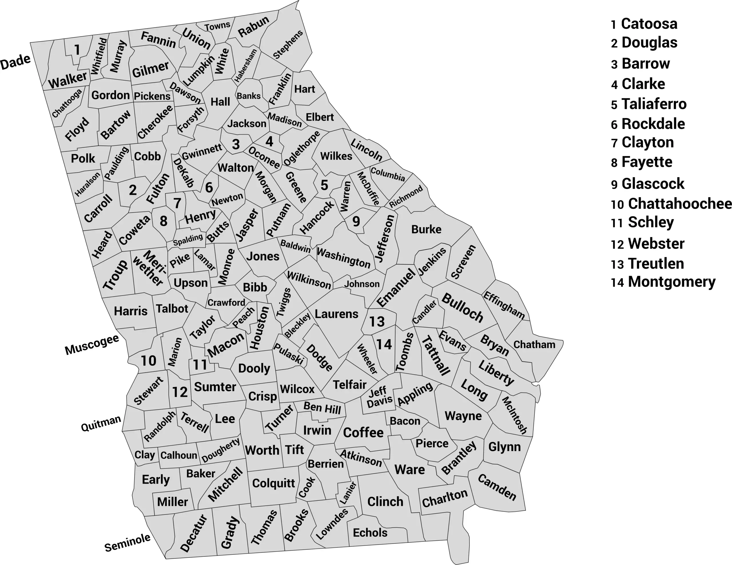
🗺️ Georgia County Map (With and Without Labels)
Georgia, known as the Peach State, blends Southern charm with a diverse landscape — from mountain ranges and rolling farmland to coastal plains and bustling cities. The state is divided into 159 counties, more than almost any other state in the U.S.
Below, you’ll find two versions of the Georgia County Map: one with county labels and another blank version without labels for learning or creative projects. Both images are provided in .webp format for faster loading and crisp detail.
📍 Georgia County Map with Labels
The labeled Georgia county map below clearly marks all 159 counties, making it easy to study the geography of the state or reference specific areas.
🖼️ Georgia County Map (with labels):
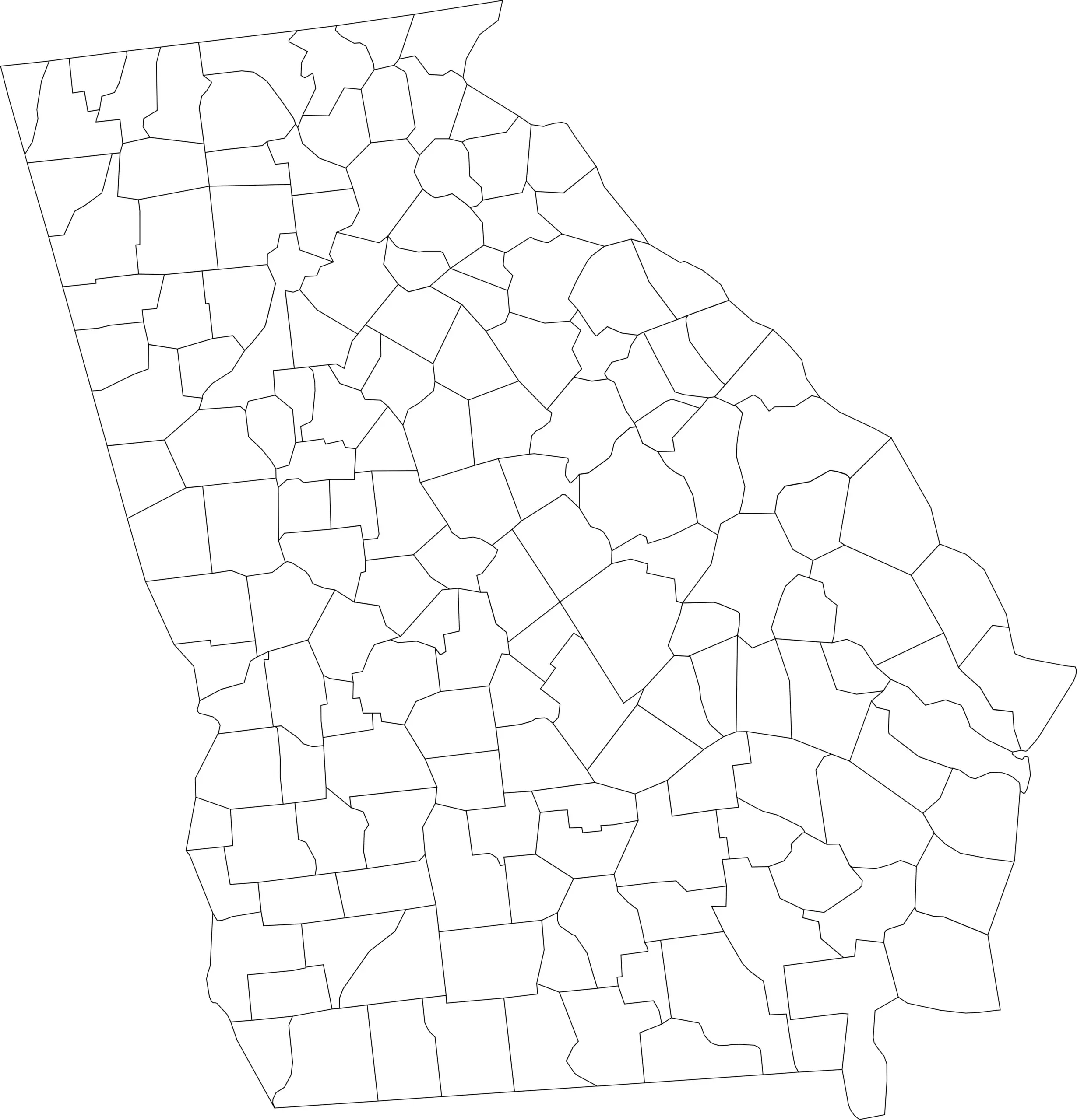
🌄 Blank Georgia County Map (No Labels)
For students, teachers, or anyone learning about Georgia’s geography, the blank county map is a great resource for labeling exercises, quizzes, or coloring activities.
🖼️ Georgia County Map (without labels):
🧭 About Georgia’s Counties
Georgia’s counties range from busy metropolitan areas to peaceful rural communities — each with unique history and landscapes.
Here are a few notable examples:
- Fulton County — Home to Atlanta, the state’s largest city and capital.
- Chatham County — Includes the historic city of Savannah and Georgia’s coastal islands.
- Cobb County — A fast-growing suburban area northwest of Atlanta.
- Muscogee County — Contains Columbus and sits along the Chattahoochee River.
- Hall County — Known for Lake Lanier, a popular recreation area.
Each county reflects a different part of Georgia’s rich culture, from mountain trails in the north to coastal marshes in the south.
🧾 Uses for the Georgia County Map
These maps are perfect for:
✅ Educational projects and geography lessons
✅ Travel planning and regional research
✅ Data visualization and demographic studies
✅ Coloring or labeling activities
✅ Classroom and homeschool resources
📥 Download Georgia County Maps
You can download the high-quality .webp map images below for fast-loading and print-friendly use:
Both maps are free for personal, educational, and non-commercial use.
Georgia Counties by Population (2025 Estimates)
Georgia has a total of 159 counties — the second-highest of any U.S. state, behind only Texas. From Atlanta’s dense urban core to the quiet rural regions of South Georgia, each county contributes to the state’s rich cultural and geographic diversity. Below is a complete list of all Georgia counties with their 2025 estimated population figures.
| County | Population (2025 est.) |
|---|---|
| Appling County | 19,783 |
| Atkinson County | 8,372 |
| Bacon County | 11,515 |
| Baker County | 2,848 |
| Baldwin County | 44,516 |
| Banks County | 20,179 |
| Barrow County | 95,427 |
| Bartow County | 113,428 |
| Ben Hill County | 16,727 |
| Berrien County | 19,089 |
| Bibb County | 155,571 |
| Bleckley County | 12,189 |
| Brantley County | 19,672 |
| Brooks County | 16,218 |
| Bryan County | 48,716 |
| Bulloch County | 89,962 |
| Burke County | 24,309 |
| Butts County | 26,851 |
| Calhoun County | 5,642 |
| Camden County | 57,912 |
| Candler County | 10,981 |
| Carroll County | 126,544 |
| Catoosa County | 70,911 |
| Charlton County | 12,332 |
| Chatham County | 305,304 |
| Chattahoochee County | 9,823 |
| Chattooga County | 25,642 |
| Cherokee County | 286,314 |
| Clarke County | 129,743 |
| Clay County | 2,758 |
| Clayton County | 299,942 |
| Clinch County | 6,679 |
| Cobb County | 772,388 |
| Coffee County | 44,301 |
| Colquitt County | 46,222 |
| Columbia County | 166,981 |
| Cook County | 17,532 |
| Coweta County | 157,298 |
| Crawford County | 12,105 |
| Crisp County | 20,883 |
| Dade County | 16,565 |
| Dawson County | 29,132 |
| Decatur County | 27,426 |
| DeKalb County | 767,813 |
| Dodge County | 19,417 |
| Dooly County | 11,934 |
| Dougherty County | 83,091 |
| Douglas County | 150,874 |
| Early County | 10,103 |
| Echols County | 3,771 |
| Effingham County | 68,001 |
| Elbert County | 19,229 |
| Emanuel County | 22,389 |
| Evans County | 10,648 |
| Fannin County | 27,273 |
| Fayette County | 124,982 |
| Floyd County | 103,496 |
| Forsyth County | 273,395 |
| Franklin County | 24,121 |
| Fulton County | 1,067,198 |
| Gilmer County | 33,889 |
| Glynn County | 86,902 |
| Gordon County | 60,361 |
| Grady County | 24,920 |
| Greene County | 19,896 |
| Gwinnett County | 991,454 |
| Habersham County | 47,923 |
| Hall County | 219,701 |
| Hancock County | 8,178 |
| Haralson County | 30,282 |
| Harris County | 37,978 |
| Hart County | 26,236 |
| Heard County | 11,204 |
| Henry County | 251,162 |
| Houston County | 173,721 |
| Irwin County | 9,309 |
| Jackson County | 85,989 |
| Jasper County | 14,297 |
| Jeff Davis County | 15,569 |
| Jefferson County | 15,285 |
| Jenkins County | 8,398 |
| Johnson County | 9,399 |
| Jones County | 29,125 |
| Lamar County | 19,408 |
| Lanier County | 10,595 |
| Laurens County | 49,913 |
| Lee County | 35,197 |
| Liberty County | 63,315 |
| Lincoln County | 7,696 |
| Long County | 22,144 |
| Lowndes County | 123,602 |
| Lumpkin County | 35,829 |
| Macon County | 12,089 |
| Madison County | 31,805 |
| Marion County | 7,658 |
| McDuffie County | 21,178 |
| McIntosh County | 10,504 |
| Meriwether County | 20,331 |
| Miller County | 5,625 |
| Mitchell County | 21,013 |
| Monroe County | 29,909 |
| Montgomery County | 8,895 |
| Morgan County | 21,707 |
| Murray County | 40,747 |
| Muscogee County | 206,511 |
| Newton County | 116,953 |
| Oconee County | 45,915 |
| Oglethorpe County | 16,648 |
| Paulding County | 182,005 |
| Peach County | 28,268 |
| Pickens County | 35,982 |
| Pierce County | 19,980 |
| Pike County | 19,068 |
| Polk County | 43,504 |
| Pulaski County | 10,662 |
| Putnam County | 23,609 |
| Quitman County | 2,354 |
| Rabun County | 18,234 |
| Randolph County | 6,914 |
| Richmond County | 208,395 |
| Rockdale County | 93,385 |
| Schley County | 5,734 |
| Screven County | 13,870 |
| Seminole County | 9,425 |
| Spalding County | 68,314 |
| Stephens County | 26,958 |
| Stewart County | 5,131 |
| Sumter County | 28,131 |
| Talbot County | 5,734 |
| Taliaferro County | 1,567 |
| Tattnall County | 24,567 |
| Taylor County | 7,746 |
| Telfair County | 13,914 |
| Terrell County | 8,844 |
| Thomas County | 46,922 |
| Tift County | 42,747 |
| Toombs County | 27,962 |
| Towns County | 12,506 |
| Treutlen County | 7,072 |
| Troup County | 73,092 |
| Turner County | 7,899 |
| Twiggs County | 7,911 |
| Union County | 26,344 |
| Upson County | 26,457 |
| Walker County | 67,986 |
| Walton County | 106,494 |
| Ware County | 34,954 |
| Warren County | 5,028 |
| Washington County | 19,459 |
| Wayne County | 30,791 |
| Webster County | 2,322 |
| Wheeler County | 7,573 |
| White County | 31,502 |
| Whitfield County | 105,230 |
| Wilcox County | 8,994 |
| Wilkes County | 9,441 |
| Wilkinson County | 8,782 |
| Worth County | 20,127 |
Source: World Population Review — Georgia Counties by Population (2025 Estimates)
FAQs About Georgia Counties and Population
How many counties are in Georgia?
Georgia has 159 counties, making it the state with the second-most counties in the U.S., behind only Texas. Each county has its own local government and administrative structure.
Why does Georgia have so many counties?
Georgia’s large number of counties is partly historical — in the 19th century, the state wanted residents to be able to travel to a county courthouse within a day on horseback. Over time, this created a large number of smaller counties.
Which county has the largest population in Georgia?
Fulton County, which includes most of Atlanta, is the most populous county with over 1 million residents as of 2025.
Which counties are the fastest-growing?
Counties in the Atlanta metro area, such as Gwinnett, Cobb, Forsyth, and Henry Counties, are experiencing rapid population growth due to urban expansion, employment opportunities, and suburban development.
Which county has the smallest population?
Taliaferro County has the smallest population in Georgia, with just over 1,500 residents. It is a very rural county in eastern Georgia.
What are the largest cities in Georgia by population?
The largest cities include Atlanta (Fulton County), Augusta (Richmond County), Columbus (Muscogee County), and Savannah (Chatham County).
Are there maps of Georgia counties?
Yes, you can view a Georgia county map with labels showing all 159 counties. A blank outline map is also available for educational or custom mapping purposes.
How does Georgia compare in population to other states?
Georgia’s estimated population in 2025 is over 10.9 million people, making it the 8th most populous state in the U.S. Most growth is concentrated in the Atlanta metropolitan area.
What regions make up Georgia?
Georgia is commonly divided into regions such as North Georgia, Central Georgia, South Georgia, the Atlanta Metro Area, and the Coastal Plain. These regions help describe economic, cultural, and geographic differences within the state.
Why is Georgia important economically?
Georgia is a major economic hub, particularly around Atlanta, which is a center for transportation, logistics, business headquarters, film, and technology. Counties like Gwinnett, Cobb, and Fulton play a major role in the state’s economic output.


