🗺️ Kentucky County Map (With and Without Labels)
Kentucky, known as the Bluegrass State, is famous for horse farms, bourbon, and the Appalachian Mountains in the east. The state is divided into 120 counties, each with its own unique history, culture, and landscape.
Below, you’ll find two versions of the Kentucky County Map — one with county labels and another blank version without labels. Both maps are provided in .webp format for fast-loading, high-quality display on your website.
📍 Kentucky County Map with Labels
The labeled Kentucky county map below clearly shows all 120 counties. This map is perfect for students, educators, travelers, or anyone studying Kentucky geography.
🖼️ Kentucky County Map (with labels):
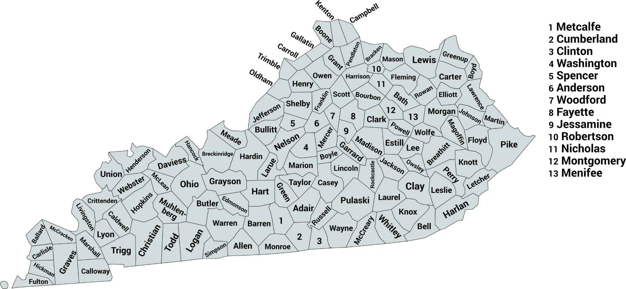
Download Labeled Kentucky County Map (.webp)
🌄 Blank Kentucky County Map (No Labels)
The blank Kentucky county map provides a clean outline of all counties without labels. It’s ideal for classroom exercises, quizzes, or creative labeling and coloring projects.
🖼️ Kentucky County Map (without labels):
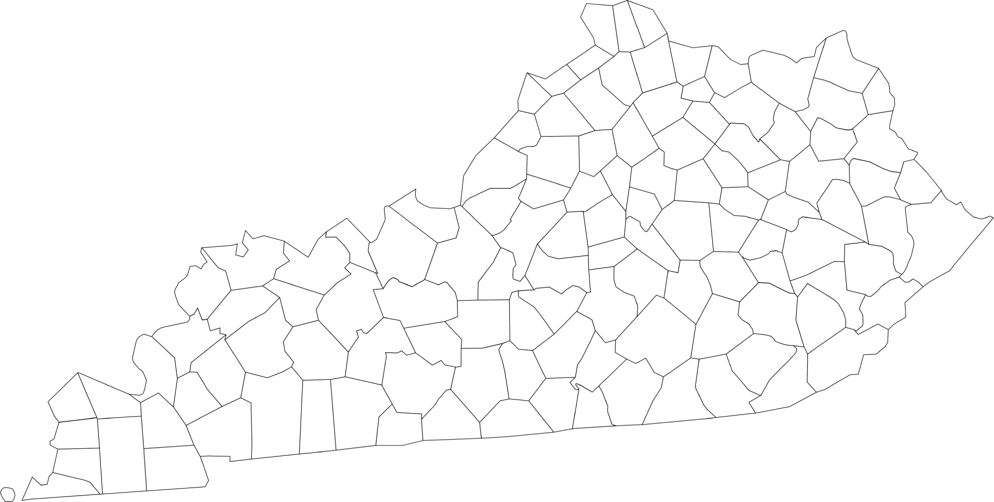
Download Blank Kentucky County Map (.webp)
🧭 About Kentucky’s Counties
Kentucky’s counties cover a mix of urban, suburban, and rural areas. Here are a few notable counties:
- Jefferson County — Home to Louisville, the largest city in Kentucky.
- Fayette County — Contains Lexington, famous for horse farms and bourbon distilleries.
- Kenton County — Part of the Cincinnati metro area in northern Kentucky.
- Boone County — Known for suburban growth and proximity to Cincinnati.
- Harlan County — Located in eastern Kentucky, known for coal mining and Appalachian culture.
Each county highlights a different aspect of Kentucky’s rich culture, economy, and natural landscapes.
🧾 Uses for the Kentucky County Map
These maps are great for:
✅ Educational activities and classroom lessons
✅ Geography quizzes and labeling exercises
✅ Travel or regional research
✅ Data visualization and county-level analysis
✅ Coloring and creative projects
📥 Download Kentucky County Maps
You can download high-quality .webp versions of both maps:
Both maps are printable, fast-loading for web, and perfect for educational, personal, or professional use.
📊 Kentucky Counties by Estimated Population (2025/Latest)
Below is a full list of all 120 counties in Kentucky with estimated county population figures (based on the most recent available 2025 or 2024 vintage estimates from U.S. Census data compiled by demographic sources). Jefferson County is the largest and Robertson County is the smallest among Kentucky’s many counties
| County | Estimated Population |
|---|---|
| Jefferson County | 804,381 |
| Fayette County | 334,250 |
| Kenton County | 177,476 |
| Warren County | 151,943 |
| Boone County | 146,759 |
| Hardin County | 112,826 |
| Daviess County | 104,457 |
| Madison County | 99,582 |
| Campbell County | 94,008 |
| Bullitt County | 85,802 |
| Christian County | 71,006 |
| Oldham County | 70,525 |
| McCracken County | 67,550 |
| Pulaski County | 66,842 |
| Laurel County | 63,353 |
| Scott County | 61,700 |
| Jessamine County | 56,495 |
| Pike County | 55,430 |
| Franklin County | 52,442 |
| Shelby County | 50,124 |
| Nelson County | 48,706 |
| Boyd County | 47,777 |
| Barren County | 45,609 |
| Hopkins County | 45,218 |
| Henderson County | 44,175 |
| Calloway County | 38,975 |
| Clark County | 37,673 |
| Whitley County | 37,233 |
| Graves County | 36,821 |
| Greenup County | 35,273 |
| Floyd County | 34,532 |
| Marshall County | 31,734 |
| Boyle County | 31,394 |
| Muhlenberg County | 30,512 |
| Meade County | 30,442 |
| Knox County | 29,657 |
| Montgomery County | 28,771 |
| Logan County | 28,467 |
| Woodford County | 27,728 |
| Grayson County | 27,070 |
| Taylor County | 26,809 |
| Perry County | 26,739 |
| Carter County | 26,098 |
| Grant County | 25,722 |
| Harlan County | 25,052 |
| Lincoln County | 24,910 |
| Anderson County | 24,883 |
| Rowan County | 24,675 |
| Ohio County | 23,933 |
| Mercer County | 23,515 |
| Bell County | 23,051 |
| Johnson County | 22,098 |
| Allen County | 22,037 |
| Breckinridge County | 21,221 |
| Spencer County | 20,823 |
| Simpson County | 20,350 |
| Bourbon County | 20,333 |
| Letcher County | 20,139 |
| Hart County | 19,923 |
| Marion County | 19,851 |
| Wayne County | 19,629 |
| Clay County | 19,592 |
| Harrison County | 19,525 |
| Adair County | 19,239 |
| Russell County | 18,458 |
| Garrard County | 18,040 |
| Mason County | 16,956 |
| McCreary County | 16,824 |
| Rockcastle County | 16,226 |
| Henry County | 16,198 |
| Fleming County | 15,### |
| Estill County | 13,### |
| Jackson County | 13,### |
| Bracken County | 8,559 |
| Gallatin County | 8,787 |
| Livingston County | 8,741 |
| Trimble County | 8,566 |
| Nicholas County | 7,958 |
| Lee County | 7,325 |
| Elliott County | 7,255 |
| Menifee County | 6,403 |
| Wolfe County | 6,358 |
| Fulton County | 6,186 |
| Cumberland County | 6,114 |
| Carlisle County | 4,812 |
| Hickman County | 4,363 |
| Owsley County | 3,872 |
| Robertson County | 2,430 |
🧠 Frequently Asked Questions About the Kentucky County Map
How many counties are in Kentucky?
Kentucky has 120 counties, one of the highest numbers of counties of any U.S. state.
Which is the largest county by population?
Jefferson County is the most populous county in Kentucky, home to Louisville, the state’s largest city, with over 770,000 residents.
Which county is the largest by land area?
Perry County and Fayette County are among the largest counties by land area, with expansive rural and urban regions.
What is the smallest county in Kentucky?
Robertson County is the smallest county by population, while Trimble County is one of the smallest by land area.
Does Kentucky use counties for local government?
Yes. Kentucky counties provide local services including law enforcement, courts, elections, property assessments, and infrastructure maintenance.
What is the Kentucky county map with labels used for?
A labeled county map helps users identify county boundaries, major cities, and regions across the state.
What is the blank Kentucky county map used for?
The blank map is ideal for educational labeling, quizzes, classroom exercises, homeschooling, or custom mapping projects.
Are Kentucky counties divided into regions?
Yes. Kentucky is commonly divided into Western Kentucky, Central Kentucky, Bluegrass Region, and Eastern Kentucky for geographic and cultural reference.
Why are Kentucky counties important for planning and governance?
Counties manage local governance, infrastructure, public services, and development planning, supporting both rural and urban communities throughout the state.
🌎 Explore More Maps
View more nearby state maps:


