🗺️ Maryland County Map (With and Without Labels)
Maryland, known as the Old Line State, offers a unique mix of coastal plains, rolling hills, and mountains. The state is divided into 24 counties plus Baltimore City, which is an independent city functioning as a county-level jurisdiction.
Below, you’ll find two versions of the Maryland County Map — one with county labels and another blank version without labels. Both are provided in .webp format for fast-loading, high-quality display on your website.
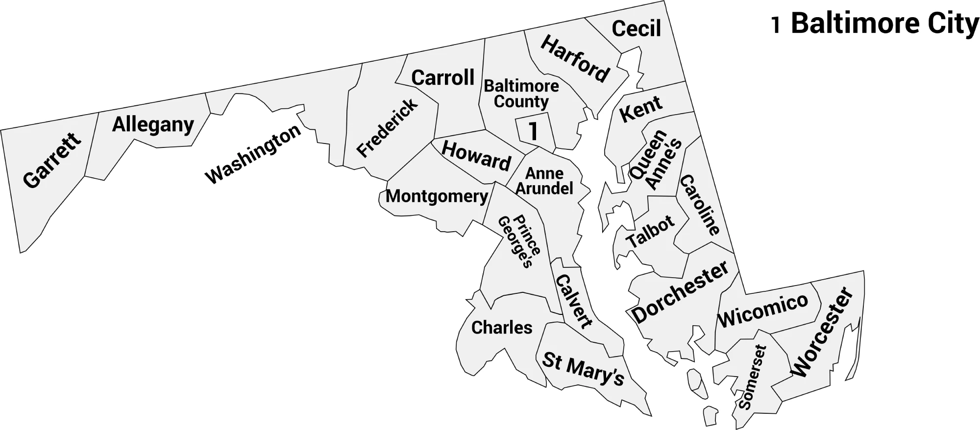
📍 Maryland County Map with Labels
The labeled Maryland county map below clearly shows all 24 counties plus Baltimore City. It’s ideal for students, educators, travelers, or anyone studying Maryland’s geography.
🖼️ Maryland County Map (with labels):
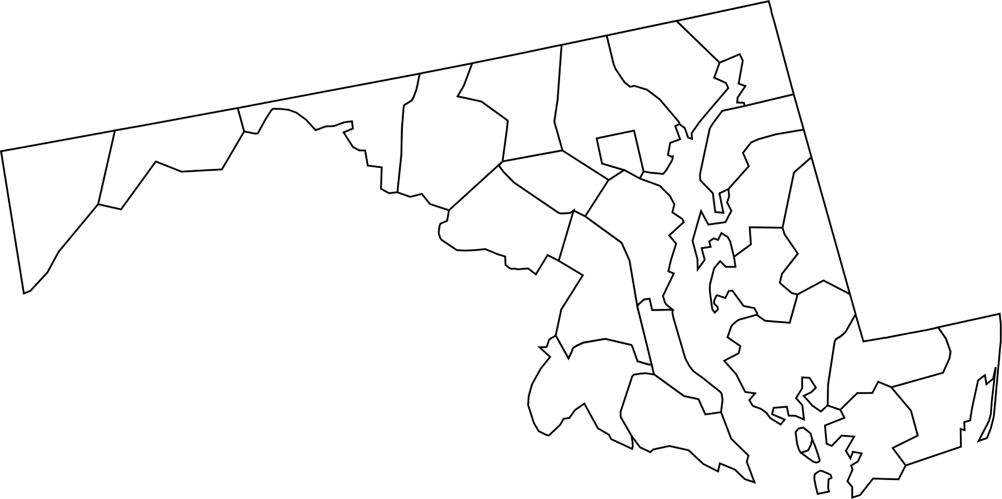
🌄 Blank Maryland County Map (No Labels)
The blank Maryland county map provides a clean outline of all counties without labels. It’s perfect for classroom exercises, quizzes, or custom labeling and coloring projects.
🖼️ Maryland County Map (without labels):
🧭 About Maryland’s Counties
Maryland’s counties include urban, suburban, and rural areas. Here are a few notable examples:
- Montgomery County — A densely populated suburban county near Washington, D.C.
- Prince George’s County — Adjacent to D.C., with major residential and commercial areas.
- Baltimore County & Baltimore City — The city and surrounding county form Maryland’s largest metro area.
- Anne Arundel County — Home to Annapolis, the state capital, and the U.S. Naval Academy.
- Harford County — Known for scenic towns and proximity to the Chesapeake Bay.
Each county showcases a different aspect of Maryland’s diverse geography, economy, and culture.
🧾 Uses for the Maryland County Map
These maps are great for:
✅ Classroom and educational use
✅ Geography quizzes and labeling exercises
✅ Travel planning and local research
✅ Data visualization and county-level analysis
✅ Coloring and creative projects
📥 Download Maryland County Maps
You can download high-quality .webp versions of both maps:
Both maps are printable, fast-loading for web, and perfect for educational, personal, or professional use.
📊 Maryland Counties by Population (Estimated)
Here’s a complete table for Maryland, including all 24 counties plus Baltimore City (independent city, county-equivalent), alphabetical, with estimated populations (2024–2025).
| County / City | Estimated Population |
|---|---|
| Allegany County | 70,000 |
| Anne Arundel County | 615,000 |
| Baltimore County | 840,000 |
| Baltimore City | 580,000 |
| Calvert County | 94,000 |
| Caroline County | 33,000 |
| Carroll County | 172,000 |
| Cecil County | 104,000 |
| Charles County | 167,000 |
| Dorchester County | 31,000 |
| Frederick County | 280,000 |
| Garrett County | 29,000 |
| Harford County | 271,000 |
| Howard County | 340,000 |
| Kent County | 20,000 |
| Montgomery County | 1,050,000 |
| Prince George’s County | 950,000 |
| Queen Anne’s County | 53,000 |
| St. Mary’s County | 116,000 |
| Somerset County | 25,000 |
| Talbot County | 36,000 |
| Washington County | 152,000 |
| Wicomico County | 101,000 |
| Worcester County | 60,000 |
🧠 Frequently Asked Questions About the Maryland County Map
How many counties are in Maryland?
Maryland has 23 counties and 1 independent city (Baltimore City), which functions similarly to a county.
Which is the largest county by population?
Montgomery County is the most populous county in Maryland, with over 1 million residents.
Which county is the largest by land area?
Baltimore County and Garrett County are among the largest by land area, with Garrett County being the largest in terms of land.
What is the smallest county in Maryland?
Kent County is the smallest by population, while Baltimore City is small in land area but densely populated.
Does Maryland use counties for local government?
Yes. Maryland counties provide essential services such as law enforcement, courts, elections, schools, and infrastructure. Baltimore City operates independently as a county-equivalent.
What is the Maryland county map with labels used for?
A labeled county map helps users identify county boundaries, major cities, and regional divisions throughout Maryland.
What is the blank Maryland county map used for?
The blank map is ideal for educational labeling, classroom activities, quizzes, homeschooling, and custom mapping projects.
Are Maryland counties divided into regions?
Yes. Maryland is often divided into regions such as Western Maryland, Central Maryland, Southern Maryland, the Eastern Shore, and the Baltimore-Washington Metro Area.
Why are Maryland counties important for planning and services?
Counties manage local governance, schools, transportation, public health, and emergency services across both urban and rural areas.
🌎 Explore More Maps
View more nearby state maps:


