🗺️ Michigan County Map (With Upper Peninsula of Michigan)
Michigan, known as the Great Lakes State, is famous for its beautiful shorelines, automotive heritage, and distinctive two-peninsula shape. The state is divided into 83 counties, each with its own mix of lakes, forests, and thriving communities.
Below, you’ll find two versions of the Michigan County Map — one with county labels and another blank version without labels. Both maps are available in .webp format for fast-loading, high-quality use on your website.
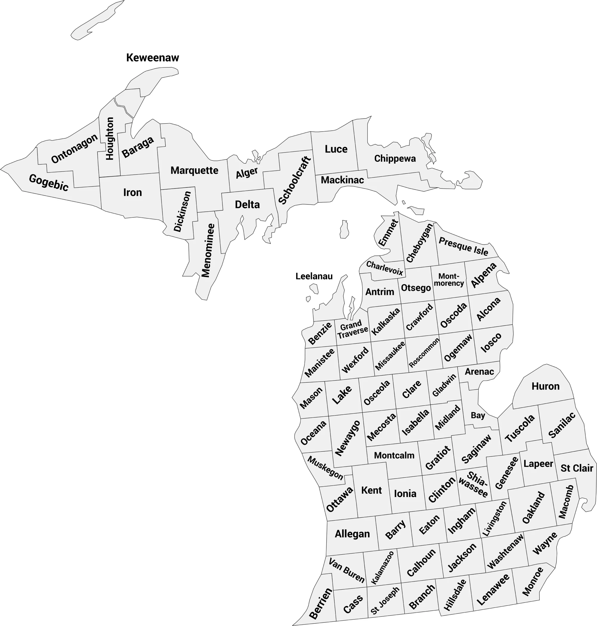
📍 Michigan County Map with Labels
The labeled Michigan county map below displays all 83 counties clearly, making it ideal for educators, students, and anyone studying Michigan’s geography or planning local projects.
🖼️ Michigan County Map (with labels):
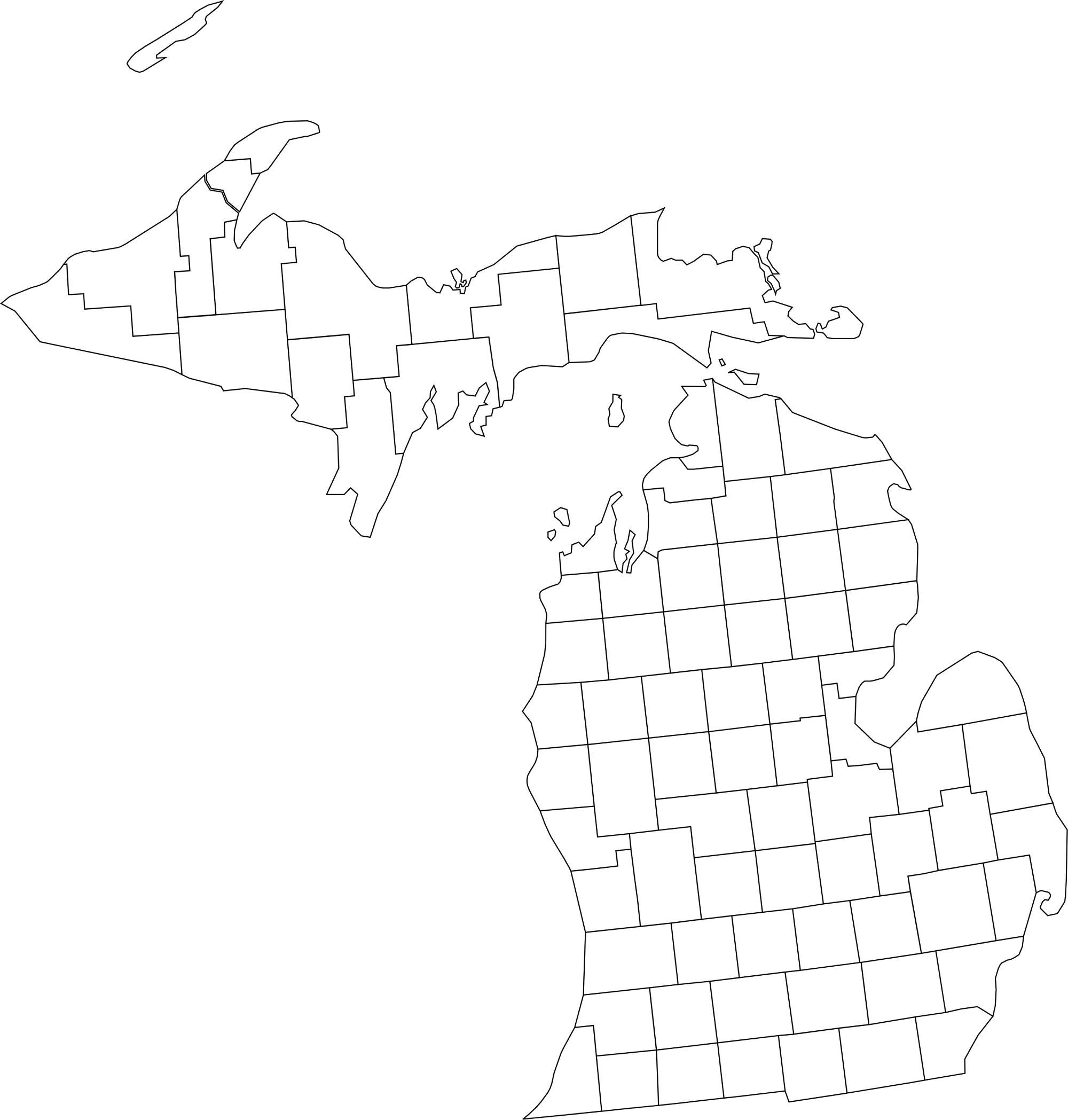
🌄 Blank Michigan County Map (No Labels)
The blank Michigan county map offers a clean, unlabeled version of the state’s county boundaries. It’s perfect for classroom activities, labeling exercises, or coloring projects.
🖼️ Michigan County Map (without labels):
🧭 About Michigan’s Counties
Michigan’s counties span two peninsulas — the Lower Peninsula, known for its urban centers and industry, and the Upper Peninsula, noted for its natural beauty and wilderness.
Here are a few notable counties:
- Wayne County — Home to Detroit, Michigan’s largest city and the heart of the auto industry.
- Oakland County — A major suburban and economic hub north of Detroit.
- Kent County — Includes Grand Rapids, a growing city known for art and craft beer.
- Marquette County — The largest county in the Upper Peninsula, known for forests and Lake Superior views.
- Washtenaw County — Home to Ann Arbor and the University of Michigan.
Each county offers a unique glimpse into the geography, economy, and culture of the state.
🧾 Uses for the Michigan County Map
These maps are excellent for:
✅ Educational lessons and geography quizzes
✅ Travel planning and regional research
✅ Data visualization and analysis
✅ County labeling or coloring projects
✅ Classroom and homeschooling activities
📥 Download Michigan County Maps
Download the high-quality .webp maps below:
Both versions are printable, lightweight, and optimized for web and classroom use.
🏙️ Michigan Counties by Population (2025)
Below is a full list of all 83 counties in Michigan with their 2025 estimated populations. Use this table for reference, maps, or data visualizations.
| County | Population (2025 est.) |
|---|---|
| Wayne County | 1,735,623 |
| Oakland County | 1,269,228 |
| Macomb County | 876,833 |
| Kent County | 666,222 |
| Genesee County | 400,720 |
| Washtenaw County | 363,600 |
| Ottawa County | 308,280 |
| Ingham County | 286,957 |
| Kalamazoo County | 264,861 |
| Livingston County | 198,003 |
| Saginaw County | 186,600 |
| Muskegon County | 178,614 |
| St. Clair County | 160,286 |
| Jackson County | 158,756 |
| Monroe County | 154,665 |
| Berrien County | 151,113 |
| Calhoun County | 133,250 |
| Allegan County | 123,237 |
| Eaton County | 108,752 |
| Bay County | 102,224 |
| Grand Traverse County | 96,667 |
| Lenawee County | 96,000 |
| Lapeer County | 89,667 |
| Midland County | 84,593 |
| Clinton County | 79,856 |
| Van Buren County | 76,056 |
| Montcalm County | 70,044 |
| Shiawassee County | 68,141 |
| Marquette County | 67,901 |
| Ionia County | 65,114 |
| Barry County | 64,620 |
| Isabella County | 63,622 |
| St. Joseph County | 61,078 |
| Tuscola County | 52,662 |
| Cass County | 51,972 |
| Newaygo County | 51,868 |
| Branch County | 46,641 |
| Hillsdale County | 45,291 |
| Gratiot County | 41,896 |
| Mecosta County | 41,733 |
| Sanilac County | 40,140 |
| Houghton County | 38,477 |
| Delta County | 36,808 |
| Chippewa County | 36,378 |
| Wexford County | 34,330 |
| Emmet County | 33,939 |
| Clare County | 31,334 |
| Huron County | 30,491 |
| Alpena County | 29,046 |
| Mason County | 28,841 |
| Oceana County | 27,103 |
| Gladwin County | 26,317 |
| Cheboygan County | 26,216 |
| Charlevoix County | 26,131 |
| Otsego County | 26,119 |
| Dickinson County | 26,060 |
| Manistee County | 25,956 |
| Iosco County | 25,173 |
| Antrim County | 24,697 |
| Roscommon County | 24,225 |
| Osceola County | 23,432 |
| Leelanau County | 23,291 |
| Menominee County | 22,385 |
| Ogemaw County | 21,132 |
| Kalkaska County | 18,982 |
| Benzie County | 18,669 |
| Missaukee County | 15,469 |
| Arenac County | 15,189 |
| Gogebic County | 13,918 |
| Crawford County | 13,746 |
| Presque Isle County | 13,169 |
| Lake County | 12,900 |
| Iron County | 11,810 |
| Alcona County | 10,673 |
| Mackinac County | 10,629 |
| Montmorency County | 9,920 |
| Oscoda County | 8,853 |
| Alger County | 8,725 |
| Baraga County | 8,364 |
| Schoolcraft County | 8,099 |
| Luce County | 6,757 |
| Ontonagon County | 5,876 |
| Keweenaw County | 2,206 |
Notes: Population figures are 2025 estimates from World Population Review.
🧠 Frequently Asked Questions About the Michigan County Map
How many counties are in Michigan?
Michigan has 83 counties, each serving as a local government unit across the state.
Which is the largest county by population?
Wayne County is the most populous county in Michigan and includes the city of Detroit, with over 1.7 million residents.
Which county is the largest by land area?
Marquette County is the largest county by land area, located in Michigan’s Upper Peninsula.
What is the smallest county in Michigan?
Keweenaw County is the smallest county by population, while Benzie County is among the smallest by land area.
Does Michigan use counties for local government?
Yes. Michigan counties provide essential services such as law enforcement, courts, elections, public health, and road maintenance.
What is the Michigan county map with labels used for?
A labeled county map helps users identify county boundaries, major cities, and regional divisions throughout Michigan.
What is the blank Michigan county map used for?
The blank map is ideal for educational labeling, classroom activities, quizzes, homeschooling, and custom mapping projects.
Are Michigan counties divided into regions?
Yes. Michigan is commonly divided into regions such as the Upper Peninsula, Northern Lower Peninsula, Central Lower Peninsula, and Southeast Michigan.
Why are Michigan counties important for government and planning?
Counties play a key role in managing transportation networks, public services, economic development, and regional planning across both rural and urban communities.
🌎 Explore More Maps
View more nearby state maps:


