🗺️ Mississippi County Map (With and Without Labels)
Mississippi, known as the Magnolia State, is rich in Southern culture, music history, and natural beauty. The state is divided into 82 counties, each contributing to its diverse landscape — from the Delta region to the Gulf Coast.
Below, you’ll find two versions of the Mississippi County Map — one with county labels and another blank version without labels. Both maps are available in .webp format for fast-loading, high-quality display on your website.
📍 Mississippi County Map with Labels
The labeled Mississippi county map below shows all 82 counties clearly marked. This version is ideal for teachers, students, travelers, and anyone exploring Mississippi’s regional geography.
🖼️ Mississippi County Map (with labels):
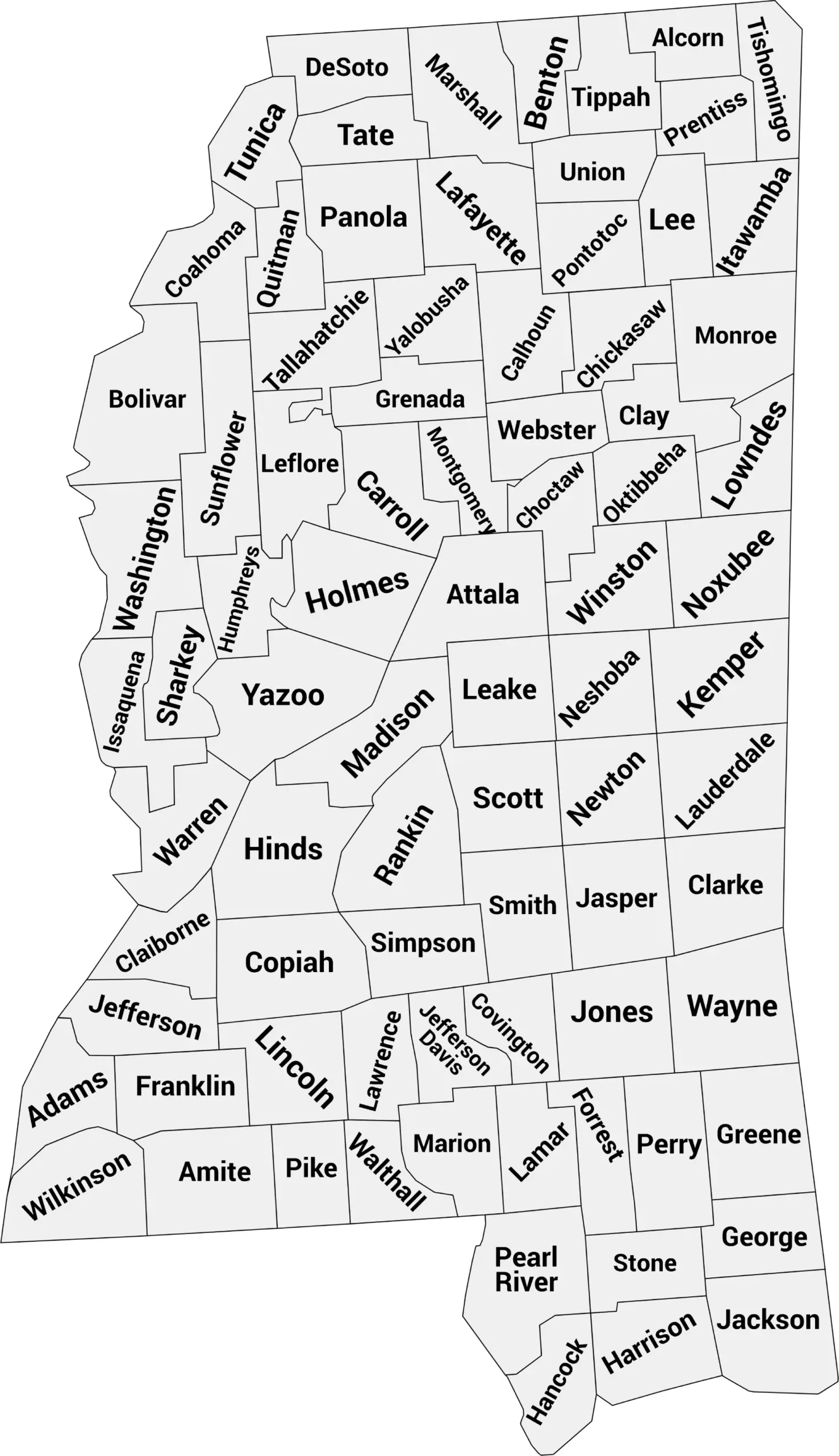
Download Labeled Mississippi County Map (.webp)
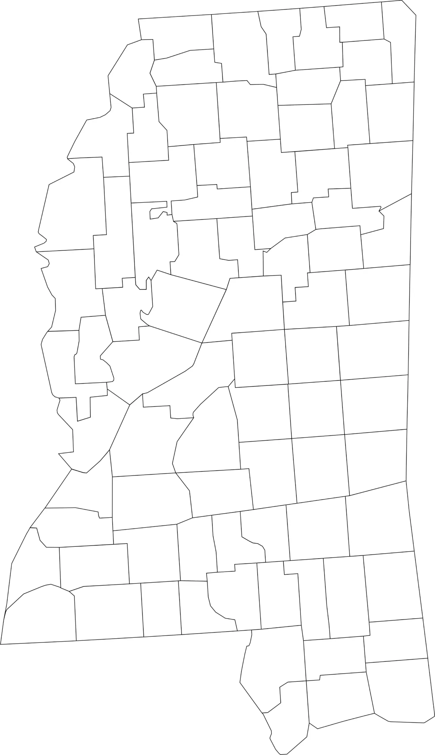
🌄 Blank Mississippi County Map (No Labels)
The blank Mississippi county map provides a simple outline of county boundaries without any text. It’s perfect for classroom activities, geography quizzes, labeling exercises, or coloring projects.
🖼️ Mississippi County Map (without labels):
🧭 About Mississippi’s Counties
Mississippi’s 82 counties range from small rural areas to bustling regional hubs. Here are a few of the most notable:
- Hinds County — Home to Jackson, the state capital.
- Harrison County — Located on the Gulf Coast, includes Biloxi and Gulfport.
- DeSoto County — A fast-growing area near Memphis, Tennessee.
- Lafayette County — Home to Oxford and the University of Mississippi (Ole Miss).
- Forrest County — Includes Hattiesburg, a major southern city and college town.
Each county adds to the cultural and economic character of the state, from blues heritage to coastal tourism.
🧾 Uses for the Mississippi County Map
These maps are excellent for:
✅ Educational lessons and geography quizzes
✅ Classroom and homeschool projects
✅ Travel planning and research
✅ Data visualization and county analysis
✅ Coloring or labeling exercises
📥 Download Mississippi County Maps
Download the high-quality .webp versions of both maps below:
Both maps are optimized for web and print — easy to load, share, and use in classrooms or reports.
📊 Mississippi Counties by Population (Estimated)
Here’s a complete population table for Mississippi, covering all 82 counties, listed alphabetically, with recent estimated populations (2024–2025).
| County | Estimated Population |
|---|---|
| Adams County | 30,000 |
| Alcorn County | 37,000 |
| Amite County | 12,000 |
| Attala County | 19,000 |
| Benton County | 8,000 |
| Bolivar County | 30,000 |
| Calhoun County | 14,000 |
| Carroll County | 10,000 |
| Chickasaw County | 17,000 |
| Choctaw County | 8,000 |
| Claiborne County | 9,000 |
| Clarke County | 15,000 |
| Clay County | 18,000 |
| Coahoma County | 23,000 |
| Copiah County | 28,000 |
| Covington County | 19,000 |
| DeSoto County | 193,000 |
| Forrest County | 76,000 |
| Franklin County | 8,000 |
| George County | 24,000 |
| Greene County | 14,000 |
| Grenada County | 21,000 |
| Hancock County | 46,000 |
| Harrison County | 208,000 |
| Hinds County | 225,000 |
| Holmes County | 17,000 |
| Humphreys County | 7,500 |
| Issaquena County | 1,300 |
| Itawamba County | 23,000 |
| Jackson County | 145,000 |
| Jasper County | 16,000 |
| Jefferson County | 7,000 |
| Jefferson Davis County | 12,000 |
| Jones County | 68,000 |
| Kemper County | 9,000 |
| Lafayette County | 57,000 |
| Lamar County | 66,000 |
| Lauderdale County | 72,000 |
| Lawrence County | 13,000 |
| Leake County | 22,000 |
| Lee County | 86,000 |
| Leflore County | 29,000 |
| Lincoln County | 34,000 |
| Lowndes County | 58,000 |
| Madison County | 110,000 |
| Marion County | 26,000 |
| Marshall County | 35,000 |
| Monroe County | 35,000 |
| Montgomery County | 9,000 |
| Neshoba County | 30,000 |
| Newton County | 21,000 |
| Noxubee County | 11,000 |
| Oktibbeha County | 49,000 |
| Panola County | 34,000 |
| Pearl River County | 56,000 |
| Perry County | 12,000 |
| Pike County | 39,000 |
| Pontotoc County | 31,000 |
| Prentiss County | 25,000 |
| Quitman County | 6,500 |
| Rankin County | 161,000 |
| Scott County | 29,000 |
| Sharkey County | 4,000 |
| Simpson County | 28,000 |
| Smith County | 15,000 |
| Stone County | 19,000 |
| Sunflower County | 26,000 |
| Tallahatchie County | 13,000 |
| Tate County | 30,000 |
| Tippah County | 22,000 |
| Tishomingo County | 19,000 |
| Tunica County | 9,500 |
| Union County | 28,000 |
| Walthall County | 14,000 |
| Warren County | 45,000 |
| Washington County | 44,000 |
| Wayne County | 19,000 |
| Webster County | 9,500 |
| Wilkinson County | 9,000 |
| Winston County | 17,000 |
| Yalobusha County | 12,000 |
| Yazoo County | 27,000 |
🧠 Frequently Asked Questions About the Mississippi County Map
How many counties are in Mississippi?
Mississippi has 82 counties, each serving as a unit of local government across the state.
Which is the largest county by population?
Hinds County is the most populous county in Mississippi and includes Jackson, the state capital.
Which county is the largest by land area?
Yazoo County is the largest county by land area in Mississippi, located in the Mississippi Delta region.
What is the smallest county in Mississippi?
Issaquena County is the smallest county by population and one of the least populated counties in the entire United States.
Does Mississippi use counties for local government?
Yes. Mississippi counties provide essential services such as law enforcement, courts, elections, public health services, and road maintenance.
What is the Mississippi county map with labels used for?
A labeled county map helps users identify county boundaries, major cities, and regional divisions throughout Mississippi.
What is the blank Mississippi county map used for?
The blank map is ideal for educational labeling, classroom activities, quizzes, homeschooling, and custom mapping projects.
Are Mississippi counties divided into regions?
Yes. Mississippi is commonly divided into regions such as the Delta, North Mississippi, Central Mississippi, South Mississippi, and the Gulf Coast.
Why are Mississippi counties important for government and planning?
Counties play a key role in managing local governance, agriculture, transportation infrastructure, emergency services, and community development across both rural and urban areas.
🌎 Explore More Maps
View more nearby state maps:


