🗺️ Illinois County Map (With and Without Labels)
Illinois, known as the Prairie State, features a mix of large cities, farmland, rivers, and forests. Divided into 102 counties, Illinois offers a wide range of geographic and cultural diversity, from the bustling cityscape of Chicago to the agricultural plains of central Illinois.
Below, you can explore two versions of the Illinois County Map: one with county labels and another blank version without labels. Both are provided in .webp format for fast-loading, high-quality images on your website.
📍 Illinois County Map with Labels
The labeled Illinois county map below clearly marks all 102 counties, making it ideal for students, educators, or anyone wanting to understand the state’s geography.
🖼️ Illinois County Map (with labels):
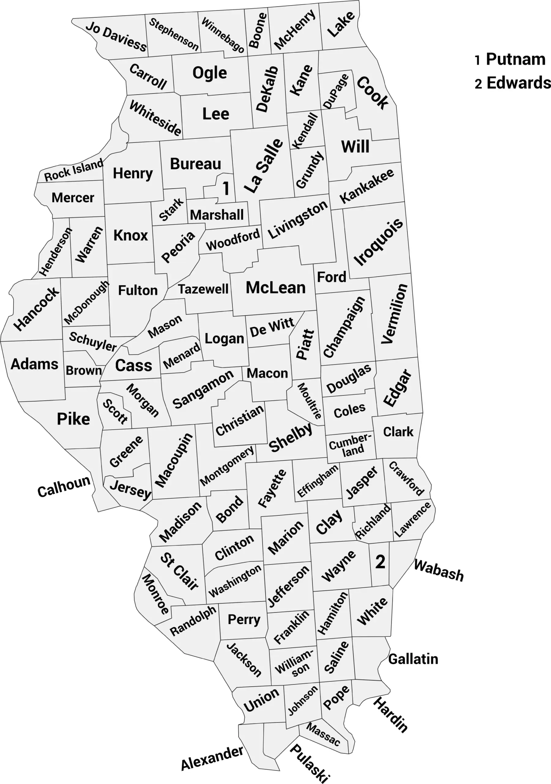
Download Labeled Illinois County Map (.webp)
🌄 Blank Illinois County Map (No Labels)
The blank Illinois county map provides a clean outline of all county borders. It’s perfect for labeling exercises, geography quizzes, classroom activities, or creative projects.
🖼️ Illinois County Map (without labels):
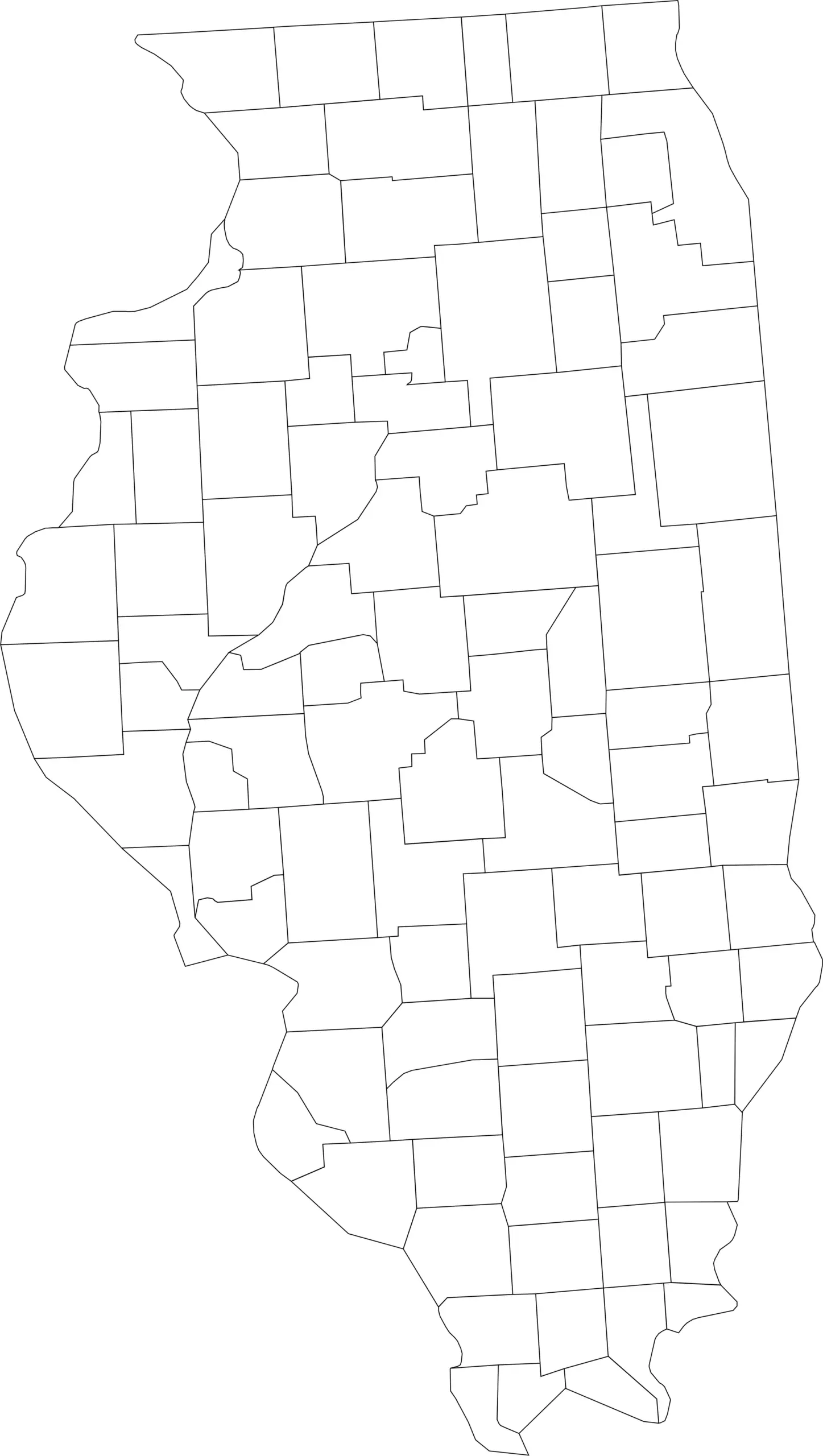
Download Blank Illinois County Map (.webp)
🧭 About Illinois’ Counties
Illinois’ counties include a mix of urban centers, small towns, and agricultural regions. Here are a few notable examples:
- Cook County — Home to Chicago, the state’s largest city and cultural hub.
- DuPage County — Part of the Chicago metropolitan area with suburban communities.
- Sangamon County — Includes Springfield, the state capital with rich historical significance.
- Lake County — Located along Lake Michigan, known for scenic views and recreation.
- Peoria County — A central Illinois county with strong agricultural and industrial history.
Each county contributes to Illinois’ economic, cultural, and geographic diversity, from lakeshores to farmland to urban centers.
🧾 Uses for the Illinois County Map
These maps are useful for:
✅ Classroom lessons and educational projects
✅ Geography quizzes and student activities
✅ Travel and regional research
✅ Data visualization and county-level analysis
✅ Coloring or labeling exercises
📥 Download Illinois County Maps
Get free, high-quality .webp versions of both maps:
Both maps are printable, fast-loading for web, and perfect for educational, personal, or professional use.
📊 Illinois Counties by Population (2025 Estimates)
Illinois has 102 counties, with populations ranging from large urban centers in the Chicago area to small rural counties downstate. Here’s a full list of all 102 counties in Illinois with their 2025 population estimates
| County | Estimated Population (2025) |
|---|---|
| Cook County | 5,182,617 |
| DuPage County | 937,142 |
| Lake County | 718,604 |
| Will County | 708,583 |
| Kane County | 520,997 |
| McHenry County | 315,959 |
| Winnebago County | 283,790 |
| Madison County | 263,017 |
| St. Clair County | 251,149 |
| Champaign County | 212,374 |
| Sangamon County | 194,345 |
| Peoria County | 179,630 |
| McLean County | 172,069 |
| Kendall County | 143,171 |
| Rock Island County | 142,731 |
| Tazewell County | 129,821 |
| LaSalle County | 108,390 |
| Kankakee County | 106,410 |
| DeKalb County | 101,335 |
| Macon County | 100,737 |
| Vermilion County | 71,106 |
| Williamson County | 67,064 |
| Adams County | 64,109 |
| Whiteside County | 54,657 |
| Grundy County | 53,835 |
| Boone County | 53,313 |
| Jackson County | 53,199 |
| Ogle County | 51,345 |
| Knox County | 48,716 |
| Henry County | 48,177 |
| Coles County | 46,423 |
| Macoupin County | 43,895 |
| Stephenson County | 43,088 |
| Woodford County | 38,290 |
| Clinton County | 37,087 |
| Franklin County | 37,033 |
| Marion County | 36,437 |
| Jefferson County | 36,107 |
| Livingston County | 35,375 |
| Monroe County | 34,969 |
| Effingham County | 34,602 |
| Lee County | 33,544 |
🔍 Quick Population Insights
- Urban vs. Rural: Most of Illinois’s population is concentrated in the northeastern part of the state around Chicago (Cook, DuPage, Lake, Will, Kane), while many downstate counties have much smaller populations.
- Population trends: Recent estimates suggest that a majority of counties in Illinois saw population declines in 2024, even as a few major counties (like Cook and DuPage) continued to grow.
🧠 Frequently Asked Questions About the Illinois County Map
How many counties are in Illinois?
Illinois has 102 counties, making it one of the states with the most counties in the U.S.
Which is the largest county by population?
Cook County is the most populous county in Illinois and includes the city of Chicago, with more than 5 million residents.
Which county is the largest by land area?
McLean County is the largest county by land area, located in central Illinois.
What is the smallest county in Illinois?
Putnam County is the smallest county by population and land area.
Does Illinois use counties for local government?
Yes. Illinois counties provide essential services such as law enforcement, courts, elections, property assessment, and infrastructure management.
What is the Illinois county map with labels used for?
A labeled county map helps users identify county boundaries, major cities, and regional divisions across the state.
What is the blank Illinois county map used for?
The blank map is ideal for educational labeling, quizzes, classroom activities, homeschooling, and custom mapping projects.
Are Illinois counties divided into regions?
Yes. Illinois is often divided into regions such as Northern Illinois, Central Illinois, Southern Illinois, and the Chicago Metropolitan Area.
Why are Illinois counties important for government and planning?
Counties play a key role in managing local services, transportation networks, agricultural regions, and urban development throughout Illinois.
🌎 Explore More Maps
View more nearby state maps:


